You are here: Home > Network List > AU - Australian Seismological Centre Stations List
> Station XMIS Christmas Island Grants Well > Earthquake Result Viewer
XMIS Christmas Island Grants Well - Earthquake Result Viewer
| Earthquake location: |
Off E. Coast Of N. Island, N.Z. |
| Earthquake latitude/longitude: |
-37.1/178.9 |
| Earthquake time(UTC): |
2016/09/01 (245) 17:01:08 GMT |
| Earthquake Depth: |
10 km |
| Earthquake Magnitude: |
5.7 MB |
| Earthquake Catalog/Contributor: |
NEIC PDE/NEIC COMCAT |
|
| Network: |
AU Australian Seismological Centre |
| Station: |
XMIS Christmas Island Grants Well |
| Lat/Lon: |
10.48 S/105.65 E |
| Elevation: |
210 m |
|
| Distance: |
70.4 deg |
| Az: |
271.553 deg |
| Baz: |
125.628 deg |
| Ray Param: |
0.05499144 |
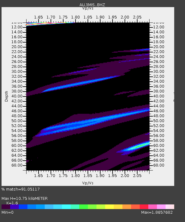
| Estimated Moho Depth: |
10.75 km |
| Estimated Crust Vp/Vs: |
1.60 |
| Assumed Crust Vp: |
4.157 km/s |
| Estimated Crust Vs: |
2.598 km/s |
| Estimated Crust Poisson's Ratio: |
0.18 |
|
| Radial Match: |
91.05117 % |
| Radial Bump: |
312 |
| Transverse Match: |
40.936417 % |
| Transverse Bump: |
334 |
| SOD ConfigId: |
11737051 |
| Insert Time: |
2019-04-25 10:04:06.771 +0000 |
| GWidth: |
2.5 |
| Max Bumps: |
400 |
| Tol: |
0.001 |
|

Signal To Noise
| Channel | StoN | STA | LTA |
| AU:XMIS: :BHZ:20160901T17:11:50.844023Z | 0.8462944 | 6.404787E-6 | 7.5680364E-6 |
| AU:XMIS: :BHN:20160901T17:11:50.844023Z | 2.0333974 | 1.0857867E-5 | 5.339766E-6 |
| AU:XMIS: :BHE:20160901T17:11:50.844023Z | 2.213416 | 7.959637E-6 | 3.596087E-6 |
| Arrivals |
| Ps | 1.6 SECOND |
| PpPs | 6.6 SECOND |
| PsPs/PpSs | 8.2 SECOND |


