You are here: Home > Network List > AU - Australian Seismological Centre Stations List
> Station XMI Christmas Island Airport > Earthquake Result Viewer
XMI Christmas Island Airport - Earthquake Result Viewer
| Earthquake location: |
Off E. Coast Of N. Island, N.Z. |
| Earthquake latitude/longitude: |
-37.1/178.9 |
| Earthquake time(UTC): |
2016/09/01 (245) 17:01:08 GMT |
| Earthquake Depth: |
10 km |
| Earthquake Magnitude: |
5.7 MB |
| Earthquake Catalog/Contributor: |
NEIC PDE/NEIC COMCAT |
|
| Network: |
AU Australian Seismological Centre |
| Station: |
XMI Christmas Island Airport |
| Lat/Lon: |
10.45 S/105.69 E |
| Elevation: |
252 m |
|
| Distance: |
70.4 deg |
| Az: |
271.601 deg |
| Baz: |
125.638 deg |
| Ray Param: |
0.054998986 |
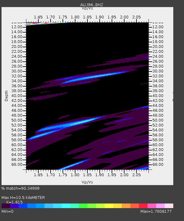
| Estimated Moho Depth: |
10.5 km |
| Estimated Crust Vp/Vs: |
1.62 |
| Assumed Crust Vp: |
4.157 km/s |
| Estimated Crust Vs: |
2.574 km/s |
| Estimated Crust Poisson's Ratio: |
0.19 |
|
| Radial Match: |
90.34989 % |
| Radial Bump: |
349 |
| Transverse Match: |
40.211056 % |
| Transverse Bump: |
365 |
| SOD ConfigId: |
11737051 |
| Insert Time: |
2019-04-25 10:04:06.921 +0000 |
| GWidth: |
2.5 |
| Max Bumps: |
400 |
| Tol: |
0.001 |
|

Signal To Noise
| Channel | StoN | STA | LTA |
| AU:XMI: :BHZ:20160901T17:11:50.769011Z | 0.77951896 | 5.999797E-6 | 7.6967945E-6 |
| AU:XMI: :BHN:20160901T17:11:50.769011Z | 1.6990705 | 9.796429E-6 | 5.7657585E-6 |
| AU:XMI: :BHE:20160901T17:11:50.769011Z | 2.5272868 | 9.463396E-6 | 3.7444888E-6 |
| Arrivals |
| Ps | 1.6 SECOND |
| PpPs | 6.5 SECOND |
| PsPs/PpSs | 8.1 SECOND |


