You are here: Home > Network List > C1 - Red Sismologica Nacional Stations List
> Station CO02 Combarbala > Earthquake Result Viewer
CO02 Combarbala - Earthquake Result Viewer
| Earthquake location: |
Off E. Coast Of N. Island, N.Z. |
| Earthquake latitude/longitude: |
-37.0/179.0 |
| Earthquake time(UTC): |
2016/09/01 (245) 17:14:05 GMT |
| Earthquake Depth: |
14 km |
| Earthquake Magnitude: |
5.7 MB |
| Earthquake Catalog/Contributor: |
NEIC PDE/NEIC COMCAT |
|
| Network: |
C1 Red Sismologica Nacional |
| Station: |
CO02 Combarbala |
| Lat/Lon: |
31.20 S/71.00 W |
| Elevation: |
1149 m |
|
| Distance: |
85.7 deg |
| Az: |
126.149 deg |
| Baz: |
228.938 deg |
| Ray Param: |
0.044564016 |
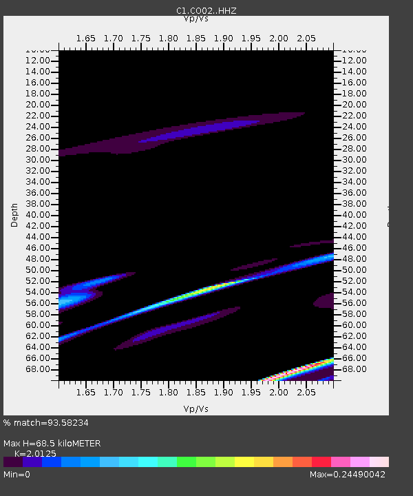
| Estimated Moho Depth: |
68.5 km |
| Estimated Crust Vp/Vs: |
2.01 |
| Assumed Crust Vp: |
6.481 km/s |
| Estimated Crust Vs: |
3.22 km/s |
| Estimated Crust Poisson's Ratio: |
0.34 |
|
| Radial Match: |
93.58234 % |
| Radial Bump: |
398 |
| Transverse Match: |
53.121277 % |
| Transverse Bump: |
400 |
| SOD ConfigId: |
11737051 |
| Insert Time: |
2019-04-25 10:08:23.140 +0000 |
| GWidth: |
2.5 |
| Max Bumps: |
400 |
| Tol: |
0.001 |
|

Signal To Noise
| Channel | StoN | STA | LTA |
| C1:CO02: :HHZ:20160901T17:26:13.178992Z | 1.7577744 | 5.4507072E-6 | 3.1009142E-6 |
| C1:CO02: :HHN:20160901T17:26:13.178992Z | 1.0792952 | 1.4312566E-6 | 1.3261031E-6 |
| C1:CO02: :HHE:20160901T17:26:13.178992Z | 0.81301016 | 4.4628164E-6 | 5.4892507E-6 |
| Arrivals |
| Ps | 11 SECOND |
| PpPs | 31 SECOND |
| PsPs/PpSs | 42 SECOND |


