You are here: Home > Network List > TA - USArray Transportable Network (new EarthScope stations) Stations List
> Station I04A Tendick Farm, Oakridge, OR, USA > Earthquake Result Viewer
I04A Tendick Farm, Oakridge, OR, USA - Earthquake Result Viewer
| Earthquake location: |
Off E. Coast Of N. Island, N.Z. |
| Earthquake latitude/longitude: |
-37.0/179.0 |
| Earthquake time(UTC): |
2016/09/01 (245) 17:14:05 GMT |
| Earthquake Depth: |
14 km |
| Earthquake Magnitude: |
5.7 MB |
| Earthquake Catalog/Contributor: |
NEIC PDE/NEIC COMCAT |
|
| Network: |
TA USArray Transportable Network (new EarthScope stations) |
| Station: |
I04A Tendick Farm, Oakridge, OR, USA |
| Lat/Lon: |
43.79 N/122.41 W |
| Elevation: |
731 m |
|
| Distance: |
96.4 deg |
| Az: |
38.453 deg |
| Baz: |
223.401 deg |
| Ray Param: |
0.04052146 |
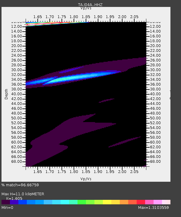
| Estimated Moho Depth: |
11.0 km |
| Estimated Crust Vp/Vs: |
1.61 |
| Assumed Crust Vp: |
6.522 km/s |
| Estimated Crust Vs: |
4.063 km/s |
| Estimated Crust Poisson's Ratio: |
0.18 |
|
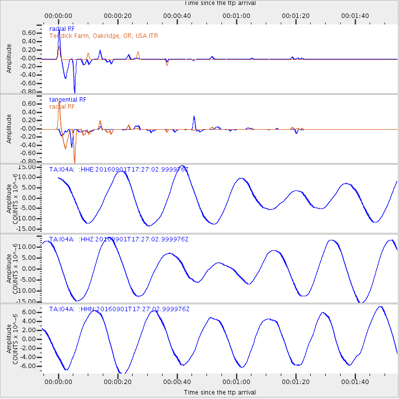
| Radial Match: |
96.66759 % |
| Radial Bump: |
276 |
| Transverse Match: |
95.66723 % |
| Transverse Bump: |
292 |
| SOD ConfigId: |
11737051 |
| Insert Time: |
2019-04-25 10:10:04.519 +0000 |
| GWidth: |
2.5 |
| Max Bumps: |
400 |
| Tol: |
0.001 |
|
Signal To Noise
| Channel | StoN | STA | LTA |
| TA:I04A: :HHZ:20160901T17:27:02.999976Z | 0.9749858 | 6.987923E-6 | 7.167205E-6 |
| TA:I04A: :HHN:20160901T17:27:02.999976Z | 2.2283869 | 5.804849E-6 | 2.6049556E-6 |
| TA:I04A: :HHE:20160901T17:27:02.999976Z | 1.5844886 | 1.3469149E-5 | 8.500628E-6 |
| Arrivals |
| Ps | 1.0 SECOND |
| PpPs | 4.3 SECOND |
| PsPs/PpSs | 5.3 SECOND |


