You are here: Home > Network List > TA - USArray Transportable Network (new EarthScope stations) Stations List
> Station J05D Fort Rock, OR, USA > Earthquake Result Viewer
J05D Fort Rock, OR, USA - Earthquake Result Viewer
| Earthquake location: |
Off E. Coast Of N. Island, N.Z. |
| Earthquake latitude/longitude: |
-37.0/179.0 |
| Earthquake time(UTC): |
2016/09/01 (245) 17:14:05 GMT |
| Earthquake Depth: |
14 km |
| Earthquake Magnitude: |
5.7 MB |
| Earthquake Catalog/Contributor: |
NEIC PDE/NEIC COMCAT |
|
| Network: |
TA USArray Transportable Network (new EarthScope stations) |
| Station: |
J05D Fort Rock, OR, USA |
| Lat/Lon: |
43.28 N/121.23 W |
| Elevation: |
1541 m |
|
| Distance: |
96.6 deg |
| Az: |
39.429 deg |
| Baz: |
224.098 deg |
| Ray Param: |
0.04045393 |
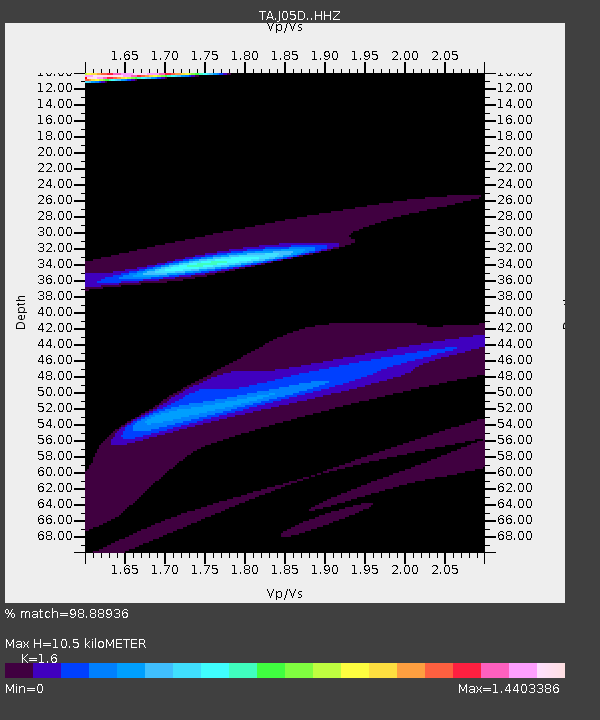
| Estimated Moho Depth: |
10.5 km |
| Estimated Crust Vp/Vs: |
1.60 |
| Assumed Crust Vp: |
6.597 km/s |
| Estimated Crust Vs: |
4.123 km/s |
| Estimated Crust Poisson's Ratio: |
0.18 |
|
| Radial Match: |
98.88936 % |
| Radial Bump: |
293 |
| Transverse Match: |
84.69507 % |
| Transverse Bump: |
400 |
| SOD ConfigId: |
11737051 |
| Insert Time: |
2019-04-25 10:10:05.527 +0000 |
| GWidth: |
2.5 |
| Max Bumps: |
400 |
| Tol: |
0.001 |
|
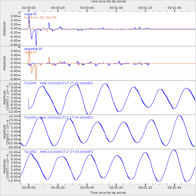
Signal To Noise
| Channel | StoN | STA | LTA |
| TA:J05D: :HHZ:20160901T17:27:04.009985Z | 0.85536766 | 8.313669E-6 | 9.719411E-6 |
| TA:J05D: :HHN:20160901T17:27:04.009985Z | 1.525526 | 1.019383E-5 | 6.6821735E-6 |
| TA:J05D: :HHE:20160901T17:27:04.009985Z | 1.5901501 | 1.2822384E-5 | 8.063631E-6 |
| Arrivals |
| Ps | 1.0 SECOND |
| PpPs | 4.0 SECOND |
| PsPs/PpSs | 5.0 SECOND |


