You are here: Home > Network List > TA - USArray Transportable Network (new EarthScope stations) Stations List
> Station S14K Fog Glacier, AK, USA > Earthquake Result Viewer
S14K Fog Glacier, AK, USA - Earthquake Result Viewer
| Earthquake location: |
Off E. Coast Of N. Island, N.Z. |
| Earthquake latitude/longitude: |
-37.0/179.0 |
| Earthquake time(UTC): |
2016/09/01 (245) 17:14:05 GMT |
| Earthquake Depth: |
14 km |
| Earthquake Magnitude: |
5.7 MB |
| Earthquake Catalog/Contributor: |
NEIC PDE/NEIC COMCAT |
|
| Network: |
TA USArray Transportable Network (new EarthScope stations) |
| Station: |
S14K Fog Glacier, AK, USA |
| Lat/Lon: |
56.28 N/159.55 W |
| Elevation: |
1059 m |
|
| Distance: |
94.7 deg |
| Az: |
11.802 deg |
| Baz: |
197.066 deg |
| Ray Param: |
0.040965617 |
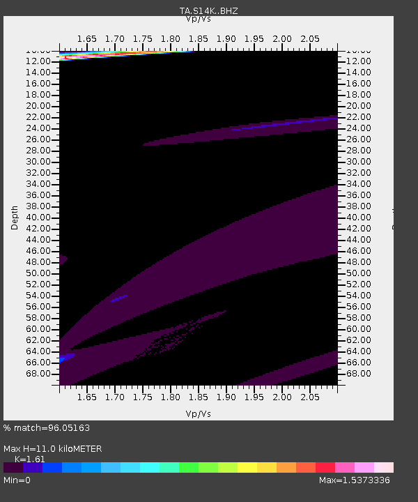
| Estimated Moho Depth: |
11.0 km |
| Estimated Crust Vp/Vs: |
1.61 |
| Assumed Crust Vp: |
6.134 km/s |
| Estimated Crust Vs: |
3.81 km/s |
| Estimated Crust Poisson's Ratio: |
0.19 |
|
| Radial Match: |
96.05163 % |
| Radial Bump: |
400 |
| Transverse Match: |
77.54475 % |
| Transverse Bump: |
400 |
| SOD ConfigId: |
11737051 |
| Insert Time: |
2019-04-25 10:10:09.123 +0000 |
| GWidth: |
2.5 |
| Max Bumps: |
400 |
| Tol: |
0.001 |
|

Signal To Noise
| Channel | StoN | STA | LTA |
| TA:S14K: :BHZ:20160901T17:26:55.350012Z | 1.7691547 | 6.34769E-6 | 3.5879793E-6 |
| TA:S14K: :BHN:20160901T17:26:55.350012Z | 2.1793973 | 1.1059283E-5 | 5.074468E-6 |
| TA:S14K: :BHE:20160901T17:26:55.350012Z | 0.7349234 | 1.796856E-6 | 2.4449569E-6 |
| Arrivals |
| Ps | 1.1 SECOND |
| PpPs | 4.6 SECOND |
| PsPs/PpSs | 5.7 SECOND |


