You are here: Home > Network List > TA - USArray Transportable Network (new EarthScope stations) Stations List
> Station R17K Ugashik Creek, AK, USA > Earthquake Result Viewer
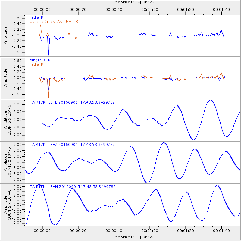
R17K Ugashik Creek, AK, USA - Earthquake Result Viewer
*The percent match for this event was below the threshold and hence no stack was calculated.
| Earthquake location: |
Off E. Coast Of N. Island, N.Z. |
| Earthquake latitude/longitude: |
-37.2/179.1 |
| Earthquake time(UTC): |
2016/09/01 (245) 17:36:00 GMT |
| Earthquake Depth: |
10 km |
| Earthquake Magnitude: |
5.6 MB |
| Earthquake Catalog/Contributor: |
NEIC PDE/NEIC COMCAT |
|
| Network: |
TA USArray Transportable Network (new EarthScope stations) |
| Station: |
R17K Ugashik Creek, AK, USA |
| Lat/Lon: |
57.64 N/156.39 W |
| Elevation: |
273 m |
|
| Distance: |
96.7 deg |
| Az: |
12.995 deg |
| Baz: |
199.509 deg |
| Ray Param: |
$rayparam |
*The percent match for this event was below the threshold and hence was not used in the summary stack. |
|
| Radial Match: |
88.79786 % |
| Radial Bump: |
365 |
| Transverse Match: |
65.467155 % |
| Transverse Bump: |
400 |
| SOD ConfigId: |
11737051 |
| Insert Time: |
2019-04-25 10:13:42.223 +0000 |
| GWidth: |
2.5 |
| Max Bumps: |
400 |
| Tol: |
0.001 |
|
Signal To Noise
| Channel | StoN | STA | LTA |
| TA:R17K: :BHZ:20160901T17:48:58.349978Z | 1.5523559 | 5.245268E-6 | 3.378908E-6 |
| TA:R17K: :BHN:20160901T17:48:58.349978Z | 0.9325056 | 2.8177624E-6 | 3.0217109E-6 |
| TA:R17K: :BHE:20160901T17:48:58.349978Z | 1.6976447 | 1.382946E-6 | 8.1462633E-7 |
| Arrivals |
| Ps | |
| PpPs | |
| PsPs/PpSs | |


