You are here: Home > Network List > CI - Caltech Regional Seismic Network Stations List
> Station PLM Palomar, Palomar Mountain, CA, USA > Earthquake Result Viewer
PLM Palomar, Palomar Mountain, CA, USA - Earthquake Result Viewer
| Earthquake location: |
Kuril Islands |
| Earthquake latitude/longitude: |
46.6/153.3 |
| Earthquake time(UTC): |
2006/11/15 (319) 11:14:13 GMT |
| Earthquake Depth: |
10 km |
| Earthquake Magnitude: |
6.5 MB, 7.8 MS, 8.3 MW, 7.9 MW |
| Earthquake Catalog/Contributor: |
WHDF/NEIC |
|
| Network: |
CI Caltech Regional Seismic Network |
| Station: |
PLM Palomar, Palomar Mountain, CA, USA |
| Lat/Lon: |
33.35 N/116.86 W |
| Elevation: |
1691 m |
|
| Distance: |
66.6 deg |
| Az: |
65.808 deg |
| Baz: |
311.273 deg |
| Ray Param: |
0.05752722 |
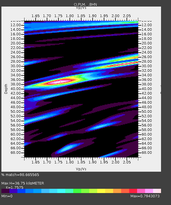
| Estimated Moho Depth: |
36.75 km |
| Estimated Crust Vp/Vs: |
1.76 |
| Assumed Crust Vp: |
6.264 km/s |
| Estimated Crust Vs: |
3.564 km/s |
| Estimated Crust Poisson's Ratio: |
0.26 |
|
| Radial Match: |
98.665565 % |
| Radial Bump: |
360 |
| Transverse Match: |
90.11566 % |
| Transverse Bump: |
400 |
| SOD ConfigId: |
2564 |
| Insert Time: |
2010-02-26 00:42:17.581 +0000 |
| GWidth: |
2.5 |
| Max Bumps: |
400 |
| Tol: |
0.001 |
|

Signal To Noise
| Channel | StoN | STA | LTA |
| CI:PLM: :BHN:20061115T11:24:32.583Z | 1.9921569 | 6.143534E-7 | 3.0838606E-7 |
| CI:PLM: :BHE:20061115T11:24:32.583Z | 2.6545594 | 7.120605E-7 | 2.6824057E-7 |
| CI:PLM: :BHZ:20061115T11:24:32.583Z | 5.8429923 | 1.3897148E-6 | 2.3784298E-7 |
| Arrivals |
| Ps | 4.6 SECOND |
| PpPs | 16 SECOND |
| PsPs/PpSs | 20 SECOND |


