You are here: Home > Network List > AV - Alaska Volcano Observatory Stations List
> Station MNAT Nateekin Bay, Makushin Volcano, Alaska > Earthquake Result Viewer
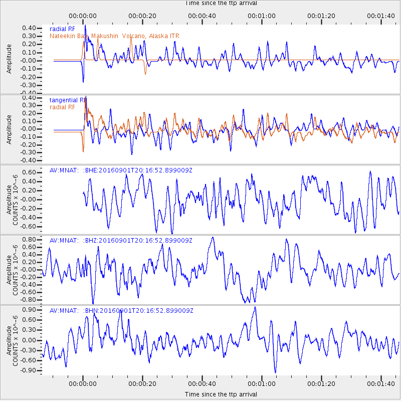
MNAT Nateekin Bay, Makushin Volcano, Alaska - Earthquake Result Viewer
*The percent match for this event was below the threshold and hence no stack was calculated.
| Earthquake location: |
Northern Sumatra, Indonesia |
| Earthquake latitude/longitude: |
0.6/98.5 |
| Earthquake time(UTC): |
2016/09/01 (245) 20:04:15 GMT |
| Earthquake Depth: |
24 km |
| Earthquake Magnitude: |
5.8 MB |
| Earthquake Catalog/Contributor: |
NEIC PDE/NEIC COMCAT |
|
| Network: |
AV Alaska Volcano Observatory |
| Station: |
MNAT Nateekin Bay, Makushin Volcano, Alaska |
| Lat/Lon: |
53.88 N/166.69 W |
| Elevation: |
390 m |
|
| Distance: |
92.4 deg |
| Az: |
36.19 deg |
| Baz: |
274.196 deg |
| Ray Param: |
$rayparam |
*The percent match for this event was below the threshold and hence was not used in the summary stack. |
|
| Radial Match: |
57.086224 % |
| Radial Bump: |
400 |
| Transverse Match: |
49.01038 % |
| Transverse Bump: |
400 |
| SOD ConfigId: |
11737051 |
| Insert Time: |
2019-04-25 10:18:35.631 +0000 |
| GWidth: |
2.5 |
| Max Bumps: |
400 |
| Tol: |
0.001 |
|
Signal To Noise
| Channel | StoN | STA | LTA |
| AV:MNAT: :BHZ:20160901T20:16:52.899009Z | 1.7098236 | 3.7647624E-7 | 2.2018426E-7 |
| AV:MNAT: :BHN:20160901T20:16:52.899009Z | 1.7611026 | 5.6247194E-7 | 3.1938623E-7 |
| AV:MNAT: :BHE:20160901T20:16:52.899009Z | 1.2513993 | 3.6427744E-7 | 2.910961E-7 |
| Arrivals |
| Ps | |
| PpPs | |
| PsPs/PpSs | |


