You are here: Home > Network List > IU - Global Seismograph Network (GSN - IRIS/USGS) Stations List
> Station PMG Port Moresby, New Guinea > Earthquake Result Viewer
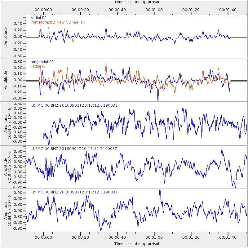
PMG Port Moresby, New Guinea - Earthquake Result Viewer
*The percent match for this event was below the threshold and hence no stack was calculated.
| Earthquake location: |
Off E. Coast Of N. Island, N.Z. |
| Earthquake latitude/longitude: |
-37.6/179.1 |
| Earthquake time(UTC): |
2016/09/01 (245) 20:06:08 GMT |
| Earthquake Depth: |
14 km |
| Earthquake Magnitude: |
5.5 MB |
| Earthquake Catalog/Contributor: |
NEIC PDE/NEIC COMCAT |
|
| Network: |
IU Global Seismograph Network (GSN - IRIS/USGS) |
| Station: |
PMG Port Moresby, New Guinea |
| Lat/Lon: |
9.40 S/147.16 E |
| Elevation: |
90 m |
|
| Distance: |
40.2 deg |
| Az: |
306.076 deg |
| Baz: |
139.438 deg |
| Ray Param: |
$rayparam |
*The percent match for this event was below the threshold and hence was not used in the summary stack. |
|
| Radial Match: |
56.042114 % |
| Radial Bump: |
400 |
| Transverse Match: |
62.060287 % |
| Transverse Bump: |
400 |
| SOD ConfigId: |
11737051 |
| Insert Time: |
2019-04-25 10:23:11.550 +0000 |
| GWidth: |
2.5 |
| Max Bumps: |
400 |
| Tol: |
0.001 |
|
Signal To Noise
| Channel | StoN | STA | LTA |
| IU:PMG:00:BHZ:20160901T20:13:12.319003Z | 0.9249902 | 4.4048173E-7 | 4.762015E-7 |
| IU:PMG:00:BH1:20160901T20:13:12.319003Z | 1.3955863 | 3.8705258E-7 | 2.773405E-7 |
| IU:PMG:00:BH2:20160901T20:13:12.319003Z | 1.0686036 | 3.0795033E-7 | 2.8818013E-7 |
| Arrivals |
| Ps | |
| PpPs | |
| PsPs/PpSs | |


