You are here: Home > Network List > GS - US Geological Survey Networks Stations List
> Station KAN12 Houston Home, Harper, KS, USA > Earthquake Result Viewer
KAN12 Houston Home, Harper, KS, USA - Earthquake Result Viewer
| Earthquake location: |
Near Coast Of Central Chile |
| Earthquake latitude/longitude: |
-31.7/-71.6 |
| Earthquake time(UTC): |
2015/09/21 (264) 17:39:58 GMT |
| Earthquake Depth: |
25 km |
| Earthquake Magnitude: |
6.5 MB, 6.5 MI, 6.6 MWW |
| Earthquake Catalog/Contributor: |
NEIC PDE/NEIC COMCAT |
|
| Network: |
GS US Geological Survey Networks |
| Station: |
KAN12 Houston Home, Harper, KS, USA |
| Lat/Lon: |
37.30 N/98.00 W |
| Elevation: |
426 m |
|
| Distance: |
73.0 deg |
| Az: |
338.263 deg |
| Baz: |
156.691 deg |
| Ray Param: |
0.053281847 |
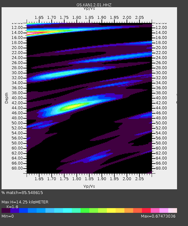
| Estimated Moho Depth: |
14.25 km |
| Estimated Crust Vp/Vs: |
1.60 |
| Assumed Crust Vp: |
6.483 km/s |
| Estimated Crust Vs: |
4.052 km/s |
| Estimated Crust Poisson's Ratio: |
0.18 |
|
| Radial Match: |
85.548615 % |
| Radial Bump: |
277 |
| Transverse Match: |
54.428505 % |
| Transverse Bump: |
400 |
| SOD ConfigId: |
1156111 |
| Insert Time: |
2015-10-05 17:52:03.132 +0000 |
| GWidth: |
2.5 |
| Max Bumps: |
400 |
| Tol: |
0.001 |
|

Signal To Noise
| Channel | StoN | STA | LTA |
| GS:KAN12:01:HHZ:20150921T17:50:55.145029Z | 20.559864 | 5.198466E-6 | 2.5284535E-7 |
| GS:KAN12:01:HHN:20150921T17:50:55.145029Z | 3.453186 | 2.176292E-6 | 6.302272E-7 |
| GS:KAN12:01:HHE:20150921T17:50:55.145029Z | 1.5174854 | 1.1505496E-6 | 7.581948E-7 |
| Arrivals |
| Ps | 1.4 SECOND |
| PpPs | 5.5 SECOND |
| PsPs/PpSs | 6.9 SECOND |


