You are here: Home > Network List > EC - Ecuador Seismic Network Stations List
> Station PULU OVPULU_S > Earthquake Result Viewer
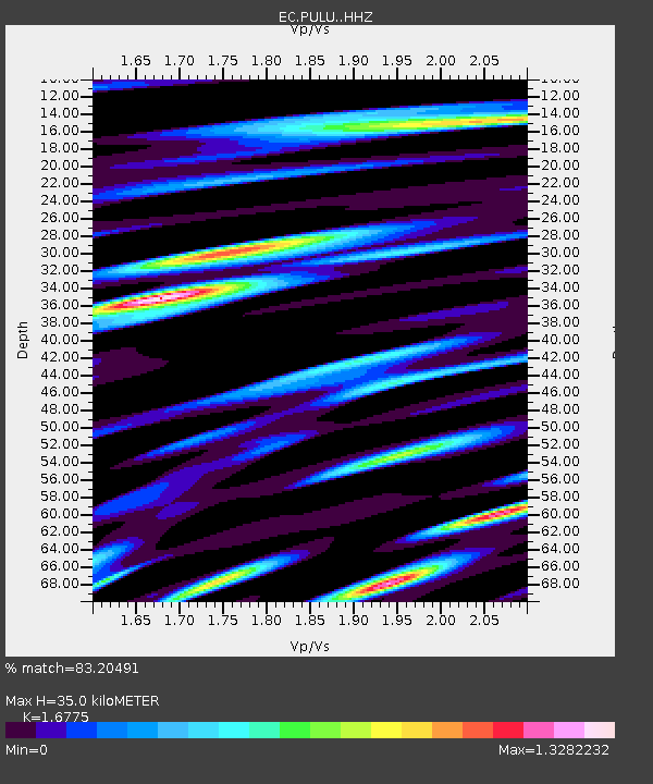
PULU OVPULU_S - Earthquake Result Viewer
| Earthquake location: |
South Sandwich Islands Region |
| Earthquake latitude/longitude: |
-55.3/-31.0 |
| Earthquake time(UTC): |
2016/09/02 (246) 01:57:53 GMT |
| Earthquake Depth: |
31 km |
| Earthquake Magnitude: |
5.6 MB |
| Earthquake Catalog/Contributor: |
NEIC PDE/NEIC COMCAT |
|
| Network: |
EC Ecuador Seismic Network |
| Station: |
PULU OVPULU_S |
| Lat/Lon: |
0.02 N/78.50 W |
| Elevation: |
3114 m |
|
| Distance: |
67.3 deg |
| Az: |
306.903 deg |
| Baz: |
152.802 deg |
| Ray Param: |
0.056983106 |
| Estimated Moho Depth: |
35.0 km |
| Estimated Crust Vp/Vs: |
1.68 |
| Assumed Crust Vp: |
6.472 km/s |
| Estimated Crust Vs: |
3.858 km/s |
| Estimated Crust Poisson's Ratio: |
0.22 |
|
| Radial Match: |
83.20491 % |
| Radial Bump: |
400 |
| Transverse Match: |
86.39463 % |
| Transverse Bump: |
400 |
| SOD ConfigId: |
11737051 |
| Insert Time: |
2019-04-25 10:25:38.783 +0000 |
| GWidth: |
2.5 |
| Max Bumps: |
400 |
| Tol: |
0.001 |
|

Signal To Noise
| Channel | StoN | STA | LTA |
| EC:PULU: :HHZ:20160902T02:08:14.85803Z | 5.540388 | 2.2111442E-6 | 3.9909554E-7 |
| EC:PULU: :HHN:20160902T02:08:14.85803Z | 1.586723 | 1.5721419E-6 | 9.908106E-7 |
| EC:PULU: :HHE:20160902T02:08:14.85803Z | 1.2782604 | 1.5512991E-6 | 1.2136018E-6 |
| Arrivals |
| Ps | 3.8 SECOND |
| PpPs | 14 SECOND |
| PsPs/PpSs | 18 SECOND |


