You are here: Home > Network List > CI - Caltech Regional Seismic Network Stations List
> Station PLM Palomar, Palomar Mountain, CA, USA > Earthquake Result Viewer
PLM Palomar, Palomar Mountain, CA, USA - Earthquake Result Viewer
| Earthquake location: |
Kuril Islands |
| Earthquake latitude/longitude: |
46.5/153.2 |
| Earthquake time(UTC): |
2006/10/01 (274) 09:06:02 GMT |
| Earthquake Depth: |
19 km |
| Earthquake Magnitude: |
6.1 MB, 6.4 MS, 6.6 MW, 6.5 MW |
| Earthquake Catalog/Contributor: |
WHDF/NEIC |
|
| Network: |
CI Caltech Regional Seismic Network |
| Station: |
PLM Palomar, Palomar Mountain, CA, USA |
| Lat/Lon: |
33.35 N/116.86 W |
| Elevation: |
1691 m |
|
| Distance: |
66.6 deg |
| Az: |
65.744 deg |
| Baz: |
311.16 deg |
| Ray Param: |
0.05746377 |
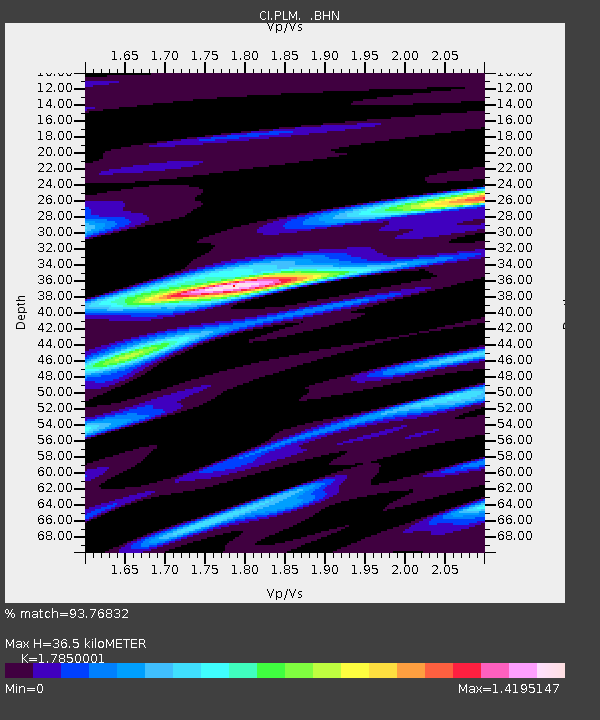
| Estimated Moho Depth: |
36.5 km |
| Estimated Crust Vp/Vs: |
1.79 |
| Assumed Crust Vp: |
6.264 km/s |
| Estimated Crust Vs: |
3.509 km/s |
| Estimated Crust Poisson's Ratio: |
0.27 |
|
| Radial Match: |
93.76832 % |
| Radial Bump: |
400 |
| Transverse Match: |
82.39794 % |
| Transverse Bump: |
400 |
| SOD ConfigId: |
2665 |
| Insert Time: |
2010-02-26 00:42:24.417 +0000 |
| GWidth: |
2.5 |
| Max Bumps: |
400 |
| Tol: |
0.001 |
|

Signal To Noise
| Channel | StoN | STA | LTA |
| CI:PLM: :BHN:20061001T09:16:20.408013Z | 1.8370137 | 2.8155432E-7 | 1.532674E-7 |
| CI:PLM: :BHE:20061001T09:16:20.408013Z | 1.316564 | 1.998077E-7 | 1.5176452E-7 |
| CI:PLM: :BHZ:20061001T09:16:20.408013Z | 7.3466783 | 6.9260733E-7 | 9.4274895E-8 |
| Arrivals |
| Ps | 4.8 SECOND |
| PpPs | 16 SECOND |
| PsPs/PpSs | 20 SECOND |


