You are here: Home > Network List > US - United States National Seismic Network Stations List
> Station MYNC Murphy, North Carolina, USA > Earthquake Result Viewer
MYNC Murphy, North Carolina, USA - Earthquake Result Viewer
| Earthquake location: |
Near West Coast Of Colombia |
| Earthquake latitude/longitude: |
4.7/-77.5 |
| Earthquake time(UTC): |
2004/11/15 (320) 09:06:56 GMT |
| Earthquake Depth: |
15 km |
| Earthquake Magnitude: |
6.6 MB, 7.1 MS, 7.2 MW, 7.1 MW |
| Earthquake Catalog/Contributor: |
WHDF/NEIC |
|
| Network: |
US United States National Seismic Network |
| Station: |
MYNC Murphy, North Carolina, USA |
| Lat/Lon: |
35.07 N/84.13 W |
| Elevation: |
550 m |
|
| Distance: |
30.8 deg |
| Az: |
349.372 deg |
| Baz: |
167.05 deg |
| Ray Param: |
0.07921926 |
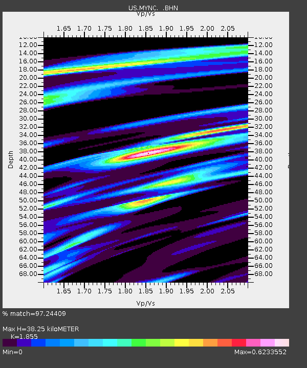
| Estimated Moho Depth: |
38.25 km |
| Estimated Crust Vp/Vs: |
1.86 |
| Assumed Crust Vp: |
6.35 km/s |
| Estimated Crust Vs: |
3.423 km/s |
| Estimated Crust Poisson's Ratio: |
0.30 |
|
| Radial Match: |
97.24409 % |
| Radial Bump: |
323 |
| Transverse Match: |
85.1807 % |
| Transverse Bump: |
400 |
| SOD ConfigId: |
110177 |
| Insert Time: |
2010-03-05 06:38:37.211 +0000 |
| GWidth: |
2.5 |
| Max Bumps: |
400 |
| Tol: |
0.001 |
|
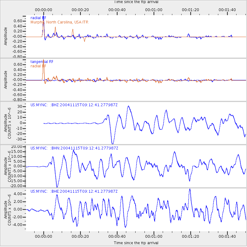
Signal To Noise
| Channel | StoN | STA | LTA |
| US:MYNC: :BHN:20041115T09:12:41.277987Z | 15.110911 | 2.9441858E-6 | 1.9483839E-7 |
| US:MYNC: :BHE:20041115T09:12:41.277987Z | 3.8683207 | 7.8862917E-7 | 2.038686E-7 |
| US:MYNC: :BHZ:20041115T09:12:41.277987Z | 13.612237 | 5.465456E-6 | 4.015105E-7 |
| Arrivals |
| Ps | 5.5 SECOND |
| PpPs | 16 SECOND |
| PsPs/PpSs | 22 SECOND |


