You are here: Home > Network List > TA - USArray Transportable Network (new EarthScope stations) Stations List
> Station J05D Fort Rock, OR, USA > Earthquake Result Viewer
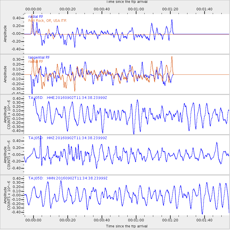
J05D Fort Rock, OR, USA - Earthquake Result Viewer
*The percent match for this event was below the threshold and hence no stack was calculated.
| Earthquake location: |
Tonga Islands |
| Earthquake latitude/longitude: |
-19.6/-173.6 |
| Earthquake time(UTC): |
2016/09/02 (246) 11:23:07 GMT |
| Earthquake Depth: |
10 km |
| Earthquake Magnitude: |
5.5 MB |
| Earthquake Catalog/Contributor: |
NEIC PDE/NEIC ALERT |
|
| Network: |
TA USArray Transportable Network (new EarthScope stations) |
| Station: |
J05D Fort Rock, OR, USA |
| Lat/Lon: |
43.28 N/121.23 W |
| Elevation: |
1541 m |
|
| Distance: |
78.9 deg |
| Az: |
36.118 deg |
| Baz: |
229.557 deg |
| Ray Param: |
$rayparam |
*The percent match for this event was below the threshold and hence was not used in the summary stack. |
|
| Radial Match: |
45.97164 % |
| Radial Bump: |
400 |
| Transverse Match: |
46.282772 % |
| Transverse Bump: |
400 |
| SOD ConfigId: |
11737051 |
| Insert Time: |
2019-04-25 10:34:37.576 +0000 |
| GWidth: |
2.5 |
| Max Bumps: |
400 |
| Tol: |
0.001 |
|
Signal To Noise
| Channel | StoN | STA | LTA |
| TA:J05D: :HHZ:20160902T11:34:38.23999Z | 1.4851981 | 1.8601484E-7 | 1.252458E-7 |
| TA:J05D: :HHN:20160902T11:34:38.23999Z | 1.464723 | 1.03790235E-7 | 7.0859976E-8 |
| TA:J05D: :HHE:20160902T11:34:38.23999Z | 0.8785276 | 1.5366435E-7 | 1.7491122E-7 |
| Arrivals |
| Ps | |
| PpPs | |
| PsPs/PpSs | |


