You are here: Home > Network List > US - United States National Seismic Network Stations List
> Station MYNC Murphy, North Carolina, USA > Earthquake Result Viewer
MYNC Murphy, North Carolina, USA - Earthquake Result Viewer
| Earthquake location: |
Kuril Islands |
| Earthquake latitude/longitude: |
44.8/147.2 |
| Earthquake time(UTC): |
2000/12/22 (357) 10:13:01 GMT |
| Earthquake Depth: |
140 km |
| Earthquake Magnitude: |
6.0 MB, 6.2 MW, 6.2 MW |
| Earthquake Catalog/Contributor: |
WHDF/NEIC |
|
| Network: |
US United States National Seismic Network |
| Station: |
MYNC Murphy, North Carolina, USA |
| Lat/Lon: |
35.07 N/84.13 W |
| Elevation: |
550 m |
|
| Distance: |
87.9 deg |
| Az: |
39.849 deg |
| Baz: |
326.202 deg |
| Ray Param: |
0.042675663 |
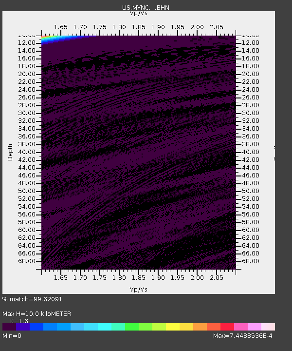
| Estimated Moho Depth: |
10.0 km |
| Estimated Crust Vp/Vs: |
1.60 |
| Assumed Crust Vp: |
6.35 km/s |
| Estimated Crust Vs: |
3.969 km/s |
| Estimated Crust Poisson's Ratio: |
0.18 |
|
| Radial Match: |
99.62091 % |
| Radial Bump: |
35 |
| Transverse Match: |
99.645386 % |
| Transverse Bump: |
38 |
| SOD ConfigId: |
110165 |
| Insert Time: |
2010-03-05 06:38:43.399 +0000 |
| GWidth: |
2.5 |
| Max Bumps: |
400 |
| Tol: |
0.001 |
|

Signal To Noise
| Channel | StoN | STA | LTA |
| US:MYNC: :BHN:20001222T10:25:03.654006Z | 0.91626185 | 3.622596E-10 | 3.9536688E-10 |
| US:MYNC: :BHE:20001222T10:25:03.654006Z | 1.0086235 | 3.657441E-10 | 3.6261705E-10 |
| US:MYNC: :BHZ:20001222T10:25:03.654006Z | 1.1686937 | 4.6018114E-10 | 3.9375683E-10 |
| Arrivals |
| Ps | 1.0 SECOND |
| PpPs | 4.0 SECOND |
| PsPs/PpSs | 5.0 SECOND |


