MYNC Murphy, North Carolina, USA - Earthquake Result Viewer
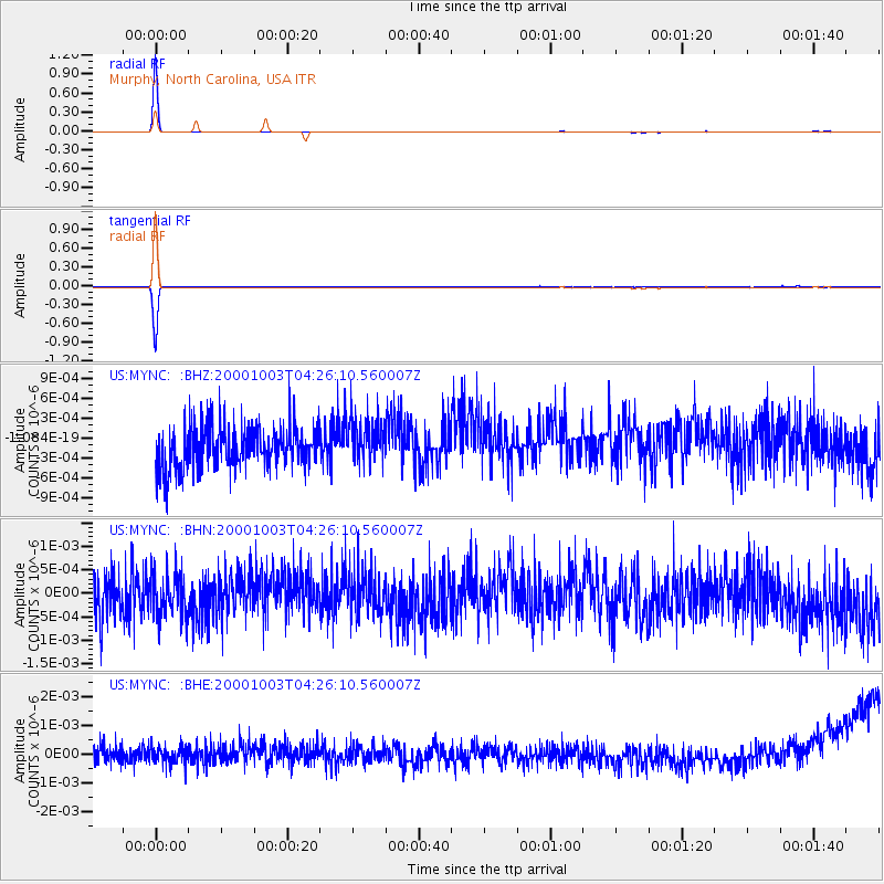
Earthquake location: Off East Coast Of Honshu, Japan
Earthquake latitude/longitude: 40.3/143.1
Earthquake time(UTC): 2000/10/03 (277) 04:13:30 GMT
Earthquake Depth: 33 km
Earthquake Magnitude: 5.6 MB, 5.7 MS, 6.1 MW, 6.0 MW
Earthquake Catalog/Contributor: WHDF/NEIC
Network: US United States National Seismic Network
Station: MYNC Murphy, North Carolina, USA
Lat/Lon: 35.07 N/84.13 W
Elevation: 550 m
Distance: 93.3 deg
Az: 37.108 deg
Baz: 325.757 deg
Ray Param: 0.041277777
Estimated Moho Depth: 41.75 km
Estimated Crust Vp/Vs: 1.97
Assumed Crust Vp: 6.35 km/s
Estimated Crust Vs: 3.227 km/s
Estimated Crust Poisson's Ratio: 0.33
Radial Match: 99.612686 %
Radial Bump: 31
Transverse Match: 99.597305 %
Transverse Bump: 32
SOD ConfigId: 110165
Insert Time: 2010-03-05 06:38:51.089 +0000
GWidth: 2.5
Max Bumps: 400
Tol: 0.001

Signal To Noise

ChannelStoNSTALTA
US:MYNC: :BHN:20001003T04:26:10.560007Z0.989682734.747213E-104.796702E-10
US:MYNC: :BHE:20001003T04:26:10.560007Z0.94054093.1115915E-103.3082997E-10
US:MYNC: :BHZ:20001003T04:26:10.560007Z1.04490393.2843114E-103.1431707E-10
Arrivals
Ps6.5 SECOND
PpPs19 SECOND
PsPs/PpSs26 SECOND