You are here: Home > Network List > US - United States National Seismic Network Stations List
> Station MYNC Murphy, North Carolina, USA > Earthquake Result Viewer
MYNC Murphy, North Carolina, USA - Earthquake Result Viewer
| Earthquake location: |
Kuril Islands |
| Earthquake latitude/longitude: |
43.0/146.8 |
| Earthquake time(UTC): |
2000/08/15 (228) 20:20:43 GMT |
| Earthquake Depth: |
33 km |
| Earthquake Magnitude: |
5.7 MB, 5.3 MS, 5.9 MW, 5.8 MW |
| Earthquake Catalog/Contributor: |
WHDF/NEIC |
|
| Network: |
US United States National Seismic Network |
| Station: |
MYNC Murphy, North Carolina, USA |
| Lat/Lon: |
35.07 N/84.13 W |
| Elevation: |
550 m |
|
| Distance: |
89.4 deg |
| Az: |
39.527 deg |
| Baz: |
325.331 deg |
| Ray Param: |
0.041806467 |
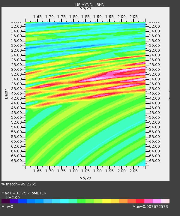
| Estimated Moho Depth: |
33.75 km |
| Estimated Crust Vp/Vs: |
2.09 |
| Assumed Crust Vp: |
6.35 km/s |
| Estimated Crust Vs: |
3.038 km/s |
| Estimated Crust Poisson's Ratio: |
0.35 |
|
| Radial Match: |
99.2265 % |
| Radial Bump: |
71 |
| Transverse Match: |
98.67076 % |
| Transverse Bump: |
55 |
| SOD ConfigId: |
110165 |
| Insert Time: |
2010-03-05 06:38:54.778 +0000 |
| GWidth: |
2.5 |
| Max Bumps: |
400 |
| Tol: |
0.001 |
|
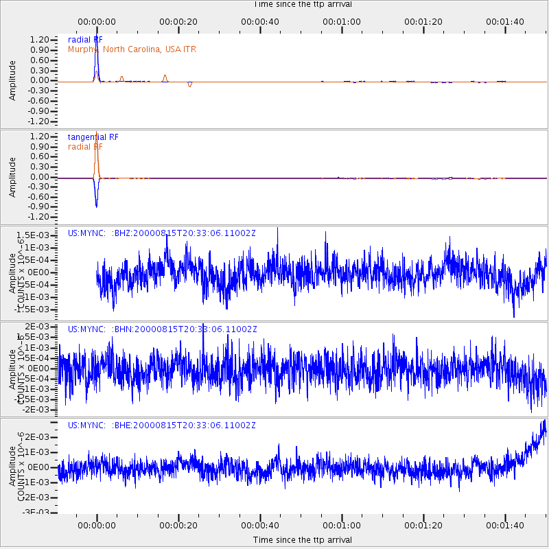
Signal To Noise
| Channel | StoN | STA | LTA |
| US:MYNC: :BHN:20000815T20:33:06.11002Z | 1.056542 | 5.6762045E-10 | 5.372436E-10 |
| US:MYNC: :BHE:20000815T20:33:06.11002Z | 1.0487187 | 4.7151666E-10 | 4.4961215E-10 |
| US:MYNC: :BHZ:20000815T20:33:06.11002Z | 1.1694417 | 5.5797966E-10 | 4.771334E-10 |
| Arrivals |
| Ps | 5.9 SECOND |
| PpPs | 16 SECOND |
| PsPs/PpSs | 22 SECOND |


