You are here: Home > Network List > US - United States National Seismic Network Stations List
> Station MYNC Murphy, North Carolina, USA > Earthquake Result Viewer
MYNC Murphy, North Carolina, USA - Earthquake Result Viewer
| Earthquake location: |
Sakhalin, Russia |
| Earthquake latitude/longitude: |
48.8/142.2 |
| Earthquake time(UTC): |
2000/08/04 (217) 21:13:02 GMT |
| Earthquake Depth: |
10 km |
| Earthquake Magnitude: |
6.3 MB, 7.1 MS, 6.8 MW, 6.7 MW |
| Earthquake Catalog/Contributor: |
WHDF/NEIC |
|
| Network: |
US United States National Seismic Network |
| Station: |
MYNC Murphy, North Carolina, USA |
| Lat/Lon: |
35.07 N/84.13 W |
| Elevation: |
550 m |
|
| Distance: |
86.9 deg |
| Az: |
36.485 deg |
| Baz: |
331.35 deg |
| Ray Param: |
0.0437444 |
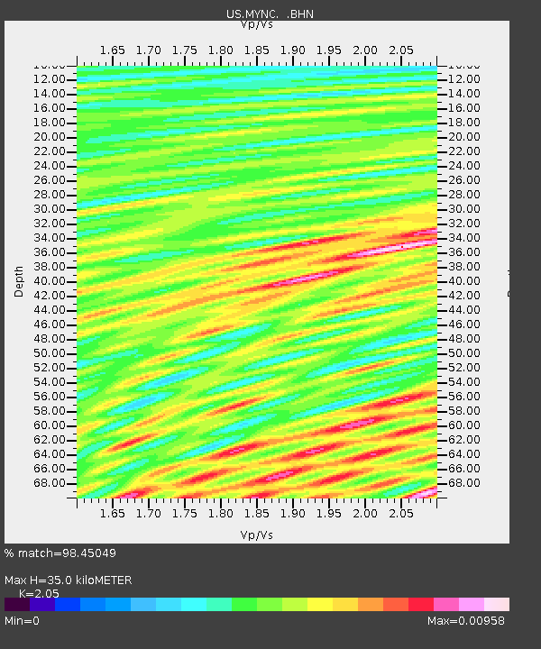
| Estimated Moho Depth: |
35.0 km |
| Estimated Crust Vp/Vs: |
2.05 |
| Assumed Crust Vp: |
6.35 km/s |
| Estimated Crust Vs: |
3.098 km/s |
| Estimated Crust Poisson's Ratio: |
0.34 |
|
| Radial Match: |
98.45049 % |
| Radial Bump: |
102 |
| Transverse Match: |
92.455734 % |
| Transverse Bump: |
285 |
| SOD ConfigId: |
110165 |
| Insert Time: |
2010-03-05 06:38:56.434 +0000 |
| GWidth: |
2.5 |
| Max Bumps: |
400 |
| Tol: |
0.001 |
|

Signal To Noise
| Channel | StoN | STA | LTA |
| US:MYNC: :BHN:20000804T21:25:15.861001Z | 1.0440264 | 5.28851E-10 | 5.0654947E-10 |
| US:MYNC: :BHE:20000804T21:25:15.861001Z | 1.269243 | 6.597953E-10 | 5.198337E-10 |
| US:MYNC: :BHZ:20000804T21:25:15.861001Z | 1.0708429 | 4.6086118E-10 | 4.3037235E-10 |
| Arrivals |
| Ps | 5.9 SECOND |
| PpPs | 16 SECOND |
| PsPs/PpSs | 22 SECOND |


