You are here: Home > Network List > US - United States National Seismic Network Stations List
> Station MYNC Murphy, North Carolina, USA > Earthquake Result Viewer
MYNC Murphy, North Carolina, USA - Earthquake Result Viewer
| Earthquake location: |
Southern Alaska |
| Earthquake latitude/longitude: |
59.2/-153.1 |
| Earthquake time(UTC): |
2000/05/19 (140) 20:34:26 GMT |
| Earthquake Depth: |
80 km |
| Earthquake Magnitude: |
5.6 MB, 5.9 MW, 5.9 MW |
| Earthquake Catalog/Contributor: |
WHDF/NEIC |
|
| Network: |
US United States National Seismic Network |
| Station: |
MYNC Murphy, North Carolina, USA |
| Lat/Lon: |
35.07 N/84.13 W |
| Elevation: |
550 m |
|
| Distance: |
50.1 deg |
| Az: |
86.83 deg |
| Baz: |
321.22 deg |
| Ray Param: |
0.06804531 |
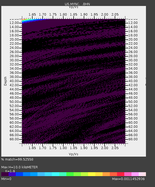
| Estimated Moho Depth: |
10.0 km |
| Estimated Crust Vp/Vs: |
1.60 |
| Assumed Crust Vp: |
6.35 km/s |
| Estimated Crust Vs: |
3.969 km/s |
| Estimated Crust Poisson's Ratio: |
0.18 |
|
| Radial Match: |
99.52558 % |
| Radial Bump: |
35 |
| Transverse Match: |
97.43611 % |
| Transverse Bump: |
72 |
| SOD ConfigId: |
110165 |
| Insert Time: |
2010-03-05 06:38:59.461 +0000 |
| GWidth: |
2.5 |
| Max Bumps: |
400 |
| Tol: |
0.001 |
|

Signal To Noise
| Channel | StoN | STA | LTA |
| US:MYNC: :BHN:20000519T20:42:42.374015Z | 1.0580703 | 5.34916E-10 | 5.0555815E-10 |
| US:MYNC: :BHE:20000519T20:42:42.374015Z | 0.98462313 | 3.8229073E-10 | 3.8826098E-10 |
| US:MYNC: :BHZ:20000519T20:42:42.374015Z | 0.8003343 | 2.712325E-10 | 3.3889905E-10 |
| Arrivals |
| Ps | 1.0 SECOND |
| PpPs | 3.8 SECOND |
| PsPs/PpSs | 4.9 SECOND |


