You are here: Home > Network List > US - United States National Seismic Network Stations List
> Station MYNC Murphy, North Carolina, USA > Earthquake Result Viewer
MYNC Murphy, North Carolina, USA - Earthquake Result Viewer
| Earthquake location: |
Sea Of Okhotsk |
| Earthquake latitude/longitude: |
46.8/144.5 |
| Earthquake time(UTC): |
2001/02/26 (057) 05:58:22 GMT |
| Earthquake Depth: |
392 km |
| Earthquake Magnitude: |
5.8 MB, 6.1 MW, 6.1 MW |
| Earthquake Catalog/Contributor: |
WHDF/NEIC |
|
| Network: |
US United States National Seismic Network |
| Station: |
MYNC Murphy, North Carolina, USA |
| Lat/Lon: |
35.07 N/84.13 W |
| Elevation: |
550 m |
|
| Distance: |
87.5 deg |
| Az: |
38.05 deg |
| Baz: |
328.93 deg |
| Ray Param: |
0.04226288 |
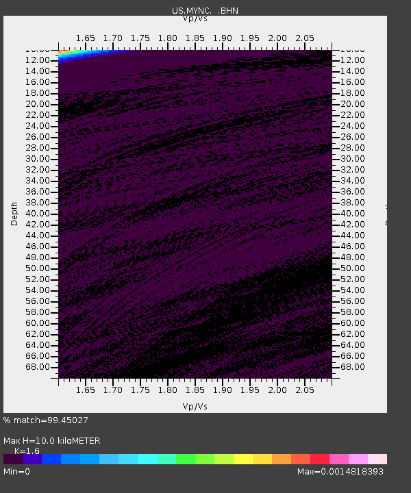
| Estimated Moho Depth: |
10.0 km |
| Estimated Crust Vp/Vs: |
1.60 |
| Assumed Crust Vp: |
6.35 km/s |
| Estimated Crust Vs: |
3.969 km/s |
| Estimated Crust Poisson's Ratio: |
0.18 |
|
| Radial Match: |
99.45027 % |
| Radial Bump: |
34 |
| Transverse Match: |
99.13623 % |
| Transverse Bump: |
39 |
| SOD ConfigId: |
110165 |
| Insert Time: |
2010-03-05 06:39:01.308 +0000 |
| GWidth: |
2.5 |
| Max Bumps: |
400 |
| Tol: |
0.001 |
|

Signal To Noise
| Channel | StoN | STA | LTA |
| US:MYNC: :BHN:20010226T06:09:55.61103Z | 1.0494168 | 4.739748E-10 | 4.5165546E-10 |
| US:MYNC: :BHE:20010226T06:09:55.61103Z | 0.9074812 | 3.5396575E-10 | 3.90053E-10 |
| US:MYNC: :BHZ:20010226T06:09:55.61103Z | 1.0423855 | 4.4290516E-10 | 4.2489579E-10 |
| Arrivals |
| Ps | 1.0 SECOND |
| PpPs | 4.0 SECOND |
| PsPs/PpSs | 5.0 SECOND |


