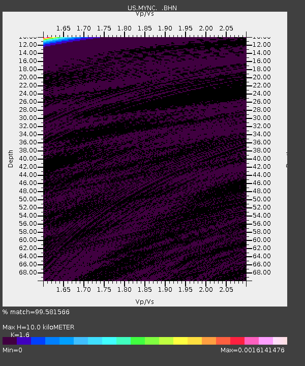
MYNC Murphy, North Carolina, USA - Earthquake Result Viewer
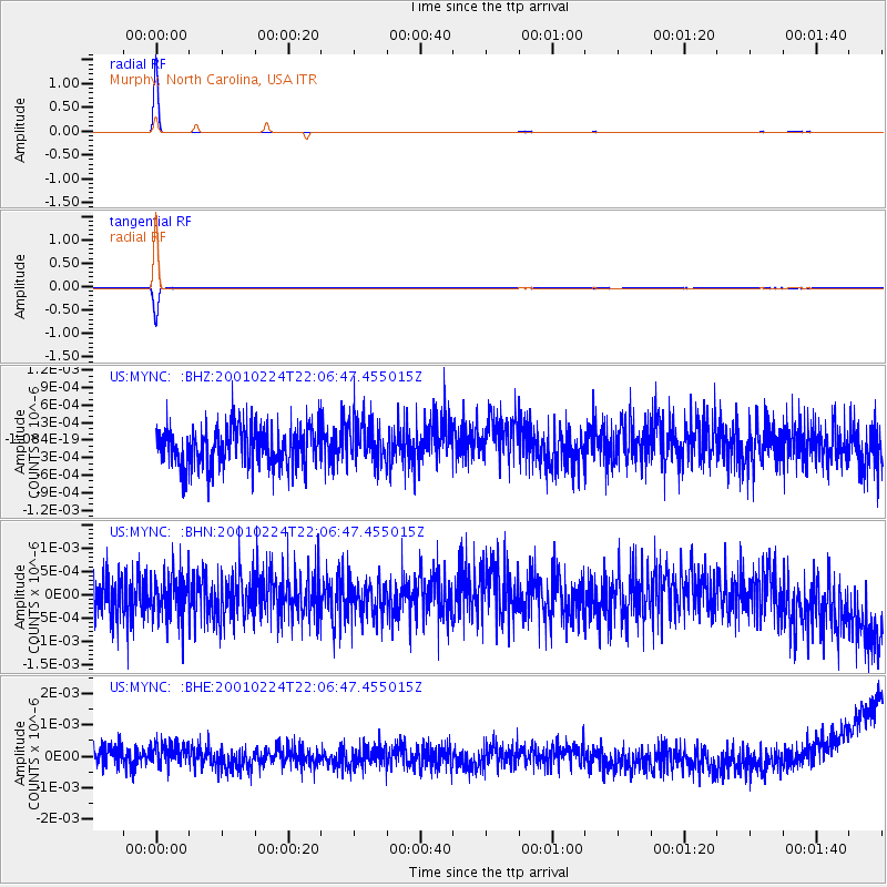
Earthquake location: Off East Coast Of Honshu, Japan
Earthquake latitude/longitude: 37.2/142.1
Earthquake time(UTC): 2001/02/24 (055) 21:53:54 GMT
Earthquake Depth: 33 km
Earthquake Magnitude: 5.4 MB, 5.5 MS, 5.9 MW, 5.8 MW
Earthquake Catalog/Contributor: WHDF/NEIC
Network: US United States National Seismic Network
Station: MYNC Murphy, North Carolina, USA
Lat/Lon: 35.07 N/84.13 W
Elevation: 550 m
Distance: 96.2 deg
Az: 36.6 deg
Baz: 324.529 deg
Ray Param: 0.040564466
Estimated Moho Depth: 10.0 km
Estimated Crust Vp/Vs: 1.60
Assumed Crust Vp: 6.35 km/s
Estimated Crust Vs: 3.969 km/s
Estimated Crust Poisson's Ratio: 0.18
Radial Match: 99.581566 %
Radial Bump: 39
Transverse Match: 99.050705 %
Transverse Bump: 62
SOD ConfigId: 110165
Insert Time: 2010-03-05 06:39:03.729 +0000
GWidth: 2.5
Max Bumps: 400
Tol: 0.001

Signal To Noise

ChannelStoNSTALTA
US:MYNC: :BHN:20010224T22:06:47.455015Z0.9731284.4653162E-104.5886214E-10
US:MYNC: :BHE:20010224T22:06:47.455015Z1.14281873.9321918E-103.4407838E-10
US:MYNC: :BHZ:20010224T22:06:47.455015Z1.08247653.6381287E-103.3609313E-10
Arrivals
Ps1.0 SECOND
PpPs4.0 SECOND
PsPs/PpSs5.0 SECOND