You are here: Home > Network List > US - United States National Seismic Network Stations List
> Station MYNC Murphy, North Carolina, USA > Earthquake Result Viewer
MYNC Murphy, North Carolina, USA - Earthquake Result Viewer
| Earthquake location: |
Kuril Islands |
| Earthquake latitude/longitude: |
43.9/147.8 |
| Earthquake time(UTC): |
2001/01/03 (003) 14:47:49 GMT |
| Earthquake Depth: |
33 km |
| Earthquake Magnitude: |
5.9 MB, 5.2 MS, 5.9 MW, 5.9 MW |
| Earthquake Catalog/Contributor: |
WHDF/NEIC |
|
| Network: |
US United States National Seismic Network |
| Station: |
MYNC Murphy, North Carolina, USA |
| Lat/Lon: |
35.07 N/84.13 W |
| Elevation: |
550 m |
|
| Distance: |
88.3 deg |
| Az: |
40.249 deg |
| Baz: |
325.311 deg |
| Ray Param: |
0.042668696 |
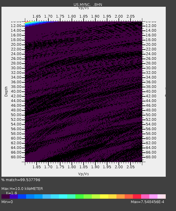
| Estimated Moho Depth: |
10.0 km |
| Estimated Crust Vp/Vs: |
1.60 |
| Assumed Crust Vp: |
6.35 km/s |
| Estimated Crust Vs: |
3.969 km/s |
| Estimated Crust Poisson's Ratio: |
0.18 |
|
| Radial Match: |
99.537796 % |
| Radial Bump: |
33 |
| Transverse Match: |
99.40804 % |
| Transverse Bump: |
43 |
| SOD ConfigId: |
110165 |
| Insert Time: |
2010-03-05 06:39:08.262 +0000 |
| GWidth: |
2.5 |
| Max Bumps: |
400 |
| Tol: |
0.001 |
|
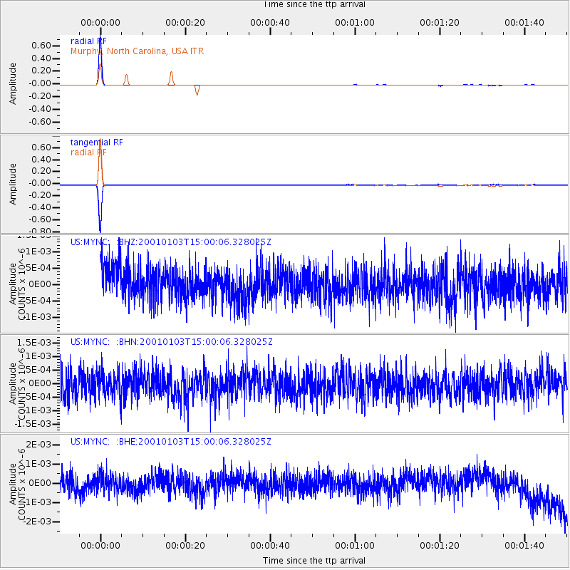
Signal To Noise
| Channel | StoN | STA | LTA |
| US:MYNC: :BHN:20010103T15:00:06.328025Z | 0.9494147 | 4.4979925E-10 | 4.737648E-10 |
| US:MYNC: :BHE:20010103T15:00:06.328025Z | 0.9445529 | 4.2206216E-10 | 4.46838E-10 |
| US:MYNC: :BHZ:20010103T15:00:06.328025Z | 1.2538048 | 5.73903E-10 | 4.5772913E-10 |
| Arrivals |
| Ps | 1.0 SECOND |
| PpPs | 4.0 SECOND |
| PsPs/PpSs | 5.0 SECOND |


