You are here: Home > Network List > US - United States National Seismic Network Stations List
> Station MYNC Murphy, North Carolina, USA > Earthquake Result Viewer
MYNC Murphy, North Carolina, USA - Earthquake Result Viewer
| Earthquake location: |
Near Coast Of Northern Chile |
| Earthquake latitude/longitude: |
-27.5/-70.6 |
| Earthquake time(UTC): |
2002/04/18 (108) 16:08:36 GMT |
| Earthquake Depth: |
62 km |
| Earthquake Magnitude: |
6.2 MB, 6.7 MW, 6.6 MW |
| Earthquake Catalog/Contributor: |
WHDF/NEIC |
|
| Network: |
US United States National Seismic Network |
| Station: |
MYNC Murphy, North Carolina, USA |
| Lat/Lon: |
35.07 N/84.13 W |
| Elevation: |
550 m |
|
| Distance: |
63.6 deg |
| Az: |
347.616 deg |
| Baz: |
166.574 deg |
| Ray Param: |
0.059342355 |
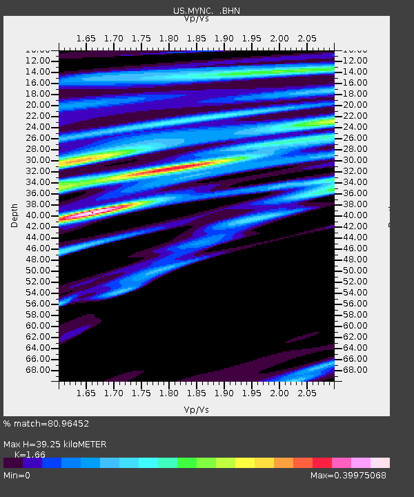
| Estimated Moho Depth: |
39.25 km |
| Estimated Crust Vp/Vs: |
1.66 |
| Assumed Crust Vp: |
6.35 km/s |
| Estimated Crust Vs: |
3.825 km/s |
| Estimated Crust Poisson's Ratio: |
0.22 |
|
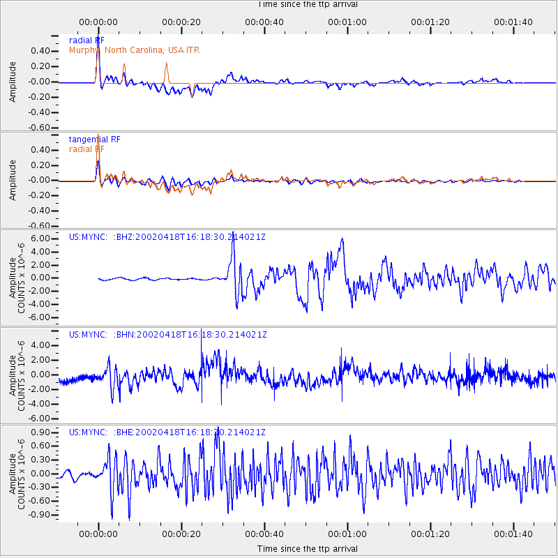
| Radial Match: |
80.96452 % |
| Radial Bump: |
400 |
| Transverse Match: |
89.540016 % |
| Transverse Bump: |
400 |
| SOD ConfigId: |
110177 |
| Insert Time: |
2010-03-05 06:39:11.707 +0000 |
| GWidth: |
2.5 |
| Max Bumps: |
400 |
| Tol: |
0.001 |
|
Signal To Noise
| Channel | StoN | STA | LTA |
| US:MYNC: :BHN:20020418T16:18:30.214021Z | 2.2633224 | 1.3781191E-6 | 6.088921E-7 |
| US:MYNC: :BHE:20020418T16:18:30.214021Z | 5.1972156 | 3.5622418E-7 | 6.8541354E-8 |
| US:MYNC: :BHZ:20020418T16:18:30.214021Z | 20.301332 | 2.8017098E-6 | 1.3800619E-7 |
| Arrivals |
| Ps | 4.3 SECOND |
| PpPs | 16 SECOND |
| PsPs/PpSs | 20 SECOND |


