You are here: Home > Network List > US - United States National Seismic Network Stations List
> Station MYNC Murphy, North Carolina, USA > Earthquake Result Viewer
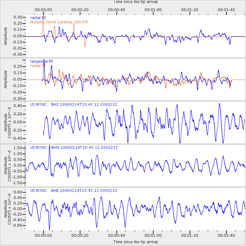
MYNC Murphy, North Carolina, USA - Earthquake Result Viewer
*The percent match for this event was below the threshold and hence no stack was calculated.
| Earthquake location: |
Kuril Islands |
| Earthquake latitude/longitude: |
45.4/150.4 |
| Earthquake time(UTC): |
1996/02/14 (045) 20:31:06 GMT |
| Earthquake Depth: |
33 km |
| Earthquake Magnitude: |
5.9 MB, 5.2 MS, 5.8 UNKNOWN, 5.8 MW |
| Earthquake Catalog/Contributor: |
WHDF/NEIC |
|
| Network: |
US United States National Seismic Network |
| Station: |
MYNC Murphy, North Carolina, USA |
| Lat/Lon: |
35.07 N/84.13 W |
| Elevation: |
550 m |
|
| Distance: |
86.0 deg |
| Az: |
42.013 deg |
| Baz: |
324.897 deg |
| Ray Param: |
$rayparam |
*The percent match for this event was below the threshold and hence was not used in the summary stack. |
|
| Radial Match: |
46.10268 % |
| Radial Bump: |
400 |
| Transverse Match: |
53.832973 % |
| Transverse Bump: |
400 |
| SOD ConfigId: |
4480 |
| Insert Time: |
2010-03-05 06:39:19.279 +0000 |
| GWidth: |
2.5 |
| Max Bumps: |
400 |
| Tol: |
0.001 |
|
Signal To Noise
| Channel | StoN | STA | LTA |
| US:MYNC: :BHN:19960214T20:43:12.036023Z | 2.3715906 | 5.9139944E-7 | 2.4936827E-7 |
| US:MYNC: :BHE:19960214T20:43:12.036023Z | 1.8309326 | 2.692388E-7 | 1.4705007E-7 |
| US:MYNC: :BHZ:19960214T20:43:12.036023Z | 1.2104828 | 1.6471526E-7 | 1.3607402E-7 |
| Arrivals |
| Ps | |
| PpPs | |
| PsPs/PpSs | |


