You are here: Home > Network List > US - United States National Seismic Network Stations List
> Station MYNC Murphy, North Carolina, USA > Earthquake Result Viewer
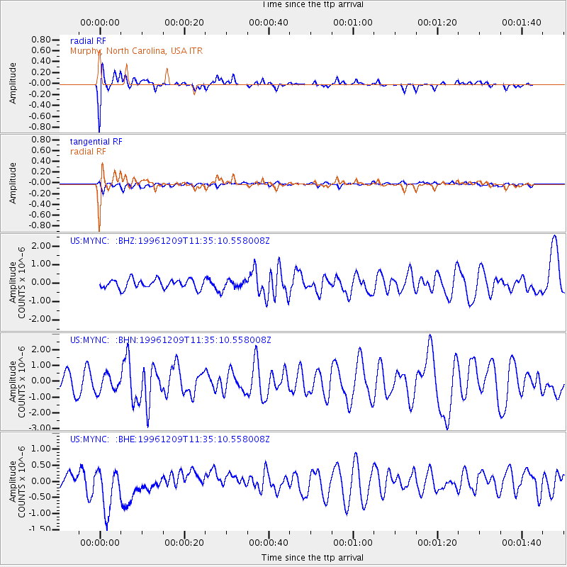
MYNC Murphy, North Carolina, USA - Earthquake Result Viewer
*The percent match for this event was below the threshold and hence no stack was calculated.
| Earthquake location: |
Northern Mid-Atlantic Ridge |
| Earthquake latitude/longitude: |
29.9/-42.9 |
| Earthquake time(UTC): |
1996/12/09 (344) 11:28:48 GMT |
| Earthquake Depth: |
10 km |
| Earthquake Magnitude: |
5.9 MB, 6.1 MS, 6.0 UNKNOWN, 5.9 MW |
| Earthquake Catalog/Contributor: |
WHDF/NEIC |
|
| Network: |
US United States National Seismic Network |
| Station: |
MYNC Murphy, North Carolina, USA |
| Lat/Lon: |
35.07 N/84.13 W |
| Elevation: |
550 m |
|
| Distance: |
35.0 deg |
| Az: |
289.509 deg |
| Baz: |
86.737 deg |
| Ray Param: |
$rayparam |
*The percent match for this event was below the threshold and hence was not used in the summary stack. |
|
| Radial Match: |
75.80878 % |
| Radial Bump: |
400 |
| Transverse Match: |
40.589367 % |
| Transverse Bump: |
400 |
| SOD ConfigId: |
4480 |
| Insert Time: |
2010-03-05 06:39:22.850 +0000 |
| GWidth: |
2.5 |
| Max Bumps: |
400 |
| Tol: |
0.001 |
|
Signal To Noise
| Channel | StoN | STA | LTA |
| US:MYNC: :BHN:19961209T11:35:10.558008Z | 1.0546272 | 5.327768E-7 | 5.0518025E-7 |
| US:MYNC: :BHE:19961209T11:35:10.558008Z | 3.351955 | 7.155093E-7 | 2.1346031E-7 |
| US:MYNC: :BHZ:19961209T11:35:10.558008Z | 0.83546513 | 2.0442795E-7 | 2.4468758E-7 |
| Arrivals |
| Ps | |
| PpPs | |
| PsPs/PpSs | |


