You are here: Home > Network List > US - United States National Seismic Network Stations List
> Station GWDE Greenwood, Delaware, USA > Earthquake Result Viewer
GWDE Greenwood, Delaware, USA - Earthquake Result Viewer

| Earthquake location: |
Peru-Ecuador Border Region |
| Earthquake latitude/longitude: |
-2.8/-77.9 |
| Earthquake time(UTC): |
1995/10/03 (276) 12:45:00 GMT |
| Earthquake Depth: |
33 km |
| Earthquake Magnitude: |
6.0 MB, 6.1 MS, 5.9 UNKNOWN, 6.4 MW |
| Earthquake Catalog/Contributor: |
WHDF/NEIC |
|
| Network: |
US United States National Seismic Network |
| Station: |
GWDE Greenwood, Delaware, USA |
| Lat/Lon: |
38.83 N/75.62 W |
| Elevation: |
19 m |
|
| Distance: |
41.5 deg |
| Az: |
2.688 deg |
| Baz: |
183.439 deg |
| Ray Param: |
0.07369292 |
| Estimated Moho Depth: |
14.0 km |
| Estimated Crust Vp/Vs: |
1.61 |
| Assumed Crust Vp: |
6.287 km/s |
| Estimated Crust Vs: |
3.917 km/s |
| Estimated Crust Poisson's Ratio: |
0.18 |
|
| Radial Match: |
89.469246 % |
| Radial Bump: |
338 |
| Transverse Match: |
62.422855 % |
| Transverse Bump: |
400 |
| SOD ConfigId: |
110177 |
| Insert Time: |
2010-03-05 06:39:29.872 +0000 |
| GWidth: |
2.5 |
| Max Bumps: |
400 |
| Tol: |
0.001 |
|
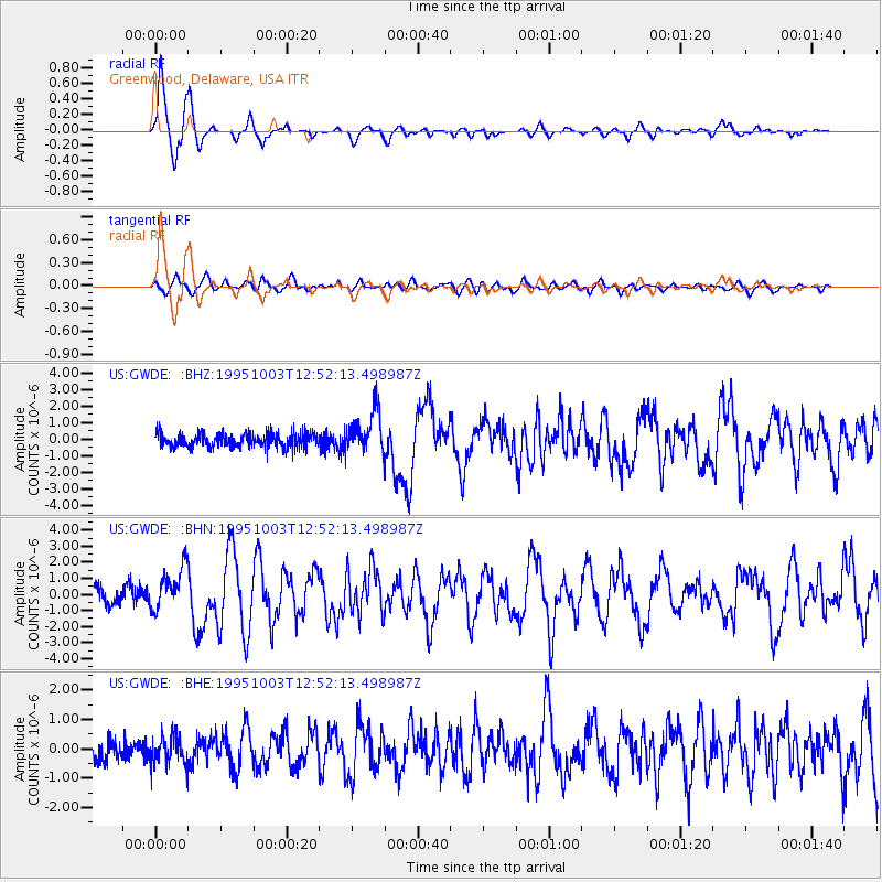
Signal To Noise
| Channel | StoN | STA | LTA |
| US:GWDE: :BHN:19951003T12:52:13.498987Z | 3.074599 | 1.2868312E-6 | 4.1853625E-7 |
| US:GWDE: :BHE:19951003T12:52:13.498987Z | 1.0450972 | 4.9013545E-7 | 4.6898552E-7 |
| US:GWDE: :BHZ:19951003T12:52:13.498987Z | 3.093358 | 1.2908487E-6 | 4.1729686E-7 |
| Arrivals |
| Ps | 1.4 SECOND |
| PpPs | 5.4 SECOND |
| PsPs/PpSs | 6.8 SECOND |


