You are here: Home > Network List > US - United States National Seismic Network Stations List
> Station GWDE Greenwood, Delaware, USA > Earthquake Result Viewer
GWDE Greenwood, Delaware, USA - Earthquake Result Viewer
| Earthquake location: |
Ecuador |
| Earthquake latitude/longitude: |
-1.3/-77.5 |
| Earthquake time(UTC): |
1999/08/28 (240) 12:40:06 GMT |
| Earthquake Depth: |
196 km |
| Earthquake Magnitude: |
5.9 MB, 6.3 MW, 6.2 MW |
| Earthquake Catalog/Contributor: |
WHDF/NEIC |
|
| Network: |
US United States National Seismic Network |
| Station: |
GWDE Greenwood, Delaware, USA |
| Lat/Lon: |
38.83 N/75.62 W |
| Elevation: |
19 m |
|
| Distance: |
40.0 deg |
| Az: |
2.35 deg |
| Baz: |
183.008 deg |
| Ray Param: |
0.07393447 |
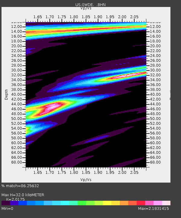
| Estimated Moho Depth: |
32.0 km |
| Estimated Crust Vp/Vs: |
2.02 |
| Assumed Crust Vp: |
6.287 km/s |
| Estimated Crust Vs: |
3.116 km/s |
| Estimated Crust Poisson's Ratio: |
0.34 |
|
| Radial Match: |
86.25632 % |
| Radial Bump: |
348 |
| Transverse Match: |
70.07078 % |
| Transverse Bump: |
400 |
| SOD ConfigId: |
110177 |
| Insert Time: |
2010-03-05 06:39:34.996 +0000 |
| GWidth: |
2.5 |
| Max Bumps: |
400 |
| Tol: |
0.001 |
|

Signal To Noise
| Channel | StoN | STA | LTA |
| US:GWDE: :BHN:19990828T12:46:50.88101Z | 1.3273878 | 1.0066329E-6 | 7.583563E-7 |
| US:GWDE: :BHE:19990828T12:46:50.88101Z | 0.8986271 | 7.4618055E-7 | 8.3035616E-7 |
| US:GWDE: :BHZ:19990828T12:46:50.88101Z | 3.89598 | 4.4650405E-6 | 1.1460636E-6 |
| Arrivals |
| Ps | 5.5 SECOND |
| PpPs | 14 SECOND |
| PsPs/PpSs | 20 SECOND |


