You are here: Home > Network List > N4 - Central and EAstern US Network Stations List
> Station V53A Sandy Mush, NC, USA > Earthquake Result Viewer
V53A Sandy Mush, NC, USA - Earthquake Result Viewer
| Earthquake location: |
Off Coast Of Northern California |
| Earthquake latitude/longitude: |
40.4/-125.7 |
| Earthquake time(UTC): |
2016/09/03 (247) 03:27:55 GMT |
| Earthquake Depth: |
2.2 km |
| Earthquake Magnitude: |
5.6 MW, 5.6 MW, 5.7 MI, 5.7 MWP |
| Earthquake Catalog/Contributor: |
NEIC PDE/NEIC COMCAT |
|
| Network: |
N4 Central and EAstern US Network |
| Station: |
V53A Sandy Mush, NC, USA |
| Lat/Lon: |
35.67 N/82.81 W |
| Elevation: |
681 m |
|
| Distance: |
33.8 deg |
| Az: |
84.064 deg |
| Baz: |
291.159 deg |
| Ray Param: |
0.07804705 |
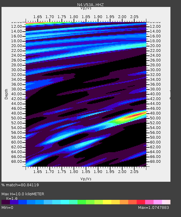
| Estimated Moho Depth: |
10.0 km |
| Estimated Crust Vp/Vs: |
1.60 |
| Assumed Crust Vp: |
6.35 km/s |
| Estimated Crust Vs: |
3.969 km/s |
| Estimated Crust Poisson's Ratio: |
0.18 |
|
| Radial Match: |
80.84119 % |
| Radial Bump: |
400 |
| Transverse Match: |
59.032757 % |
| Transverse Bump: |
400 |
| SOD ConfigId: |
11737051 |
| Insert Time: |
2019-04-25 10:40:48.633 +0000 |
| GWidth: |
2.5 |
| Max Bumps: |
400 |
| Tol: |
0.001 |
|

Signal To Noise
| Channel | StoN | STA | LTA |
| N4:V53A: :HHZ:20160903T03:34:06.770013Z | 2.6738434 | 1.5902382E-6 | 5.947387E-7 |
| N4:V53A: :HHN:20160903T03:34:06.770013Z | 1.4952372 | 3.679816E-7 | 2.461025E-7 |
| N4:V53A: :HHE:20160903T03:34:06.770013Z | 2.1742647 | 7.903367E-7 | 3.6349607E-7 |
| Arrivals |
| Ps | 1.0 SECOND |
| PpPs | 3.8 SECOND |
| PsPs/PpSs | 4.8 SECOND |


