You are here: Home > Network List > TA - USArray Transportable Network (new EarthScope stations) Stations List
> Station D23K Nanushuk River, AK USA > Earthquake Result Viewer
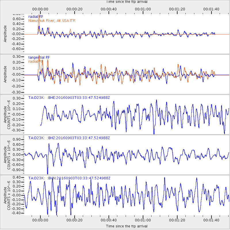
D23K Nanushuk River, AK USA - Earthquake Result Viewer
*The percent match for this event was below the threshold and hence no stack was calculated.
| Earthquake location: |
Off Coast Of Northern California |
| Earthquake latitude/longitude: |
40.4/-125.7 |
| Earthquake time(UTC): |
2016/09/03 (247) 03:27:55 GMT |
| Earthquake Depth: |
2.2 km |
| Earthquake Magnitude: |
5.6 MW, 5.6 MW, 5.7 MI, 5.7 MWP |
| Earthquake Catalog/Contributor: |
NEIC PDE/NEIC COMCAT |
|
| Network: |
TA USArray Transportable Network (new EarthScope stations) |
| Station: |
D23K Nanushuk River, AK USA |
| Lat/Lon: |
68.97 N/150.68 W |
| Elevation: |
406 m |
|
| Distance: |
31.6 deg |
| Az: |
343.034 deg |
| Baz: |
141.898 deg |
| Ray Param: |
$rayparam |
*The percent match for this event was below the threshold and hence was not used in the summary stack. |
|
| Radial Match: |
66.74095 % |
| Radial Bump: |
400 |
| Transverse Match: |
61.99715 % |
| Transverse Bump: |
400 |
| SOD ConfigId: |
11737051 |
| Insert Time: |
2019-04-25 10:42:10.190 +0000 |
| GWidth: |
2.5 |
| Max Bumps: |
400 |
| Tol: |
0.001 |
|
Signal To Noise
| Channel | StoN | STA | LTA |
| TA:D23K: :BHZ:20160903T03:33:47.524988Z | 4.3176546 | 3.363783E-7 | 7.790764E-8 |
| TA:D23K: :BHN:20160903T03:33:47.524988Z | 1.8100344 | 1.892893E-7 | 1.0457774E-7 |
| TA:D23K: :BHE:20160903T03:33:47.524988Z | 0.79095715 | 6.644864E-8 | 8.4010416E-8 |
| Arrivals |
| Ps | |
| PpPs | |
| PsPs/PpSs | |


