You are here: Home > Network List > US - United States National Seismic Network Stations List
> Station AAM Ann Arbor, Michigan, USA > Earthquake Result Viewer
AAM Ann Arbor, Michigan, USA - Earthquake Result Viewer
| Earthquake location: |
Kuril Islands |
| Earthquake latitude/longitude: |
47.2/151.3 |
| Earthquake time(UTC): |
2004/07/08 (190) 10:30:49 GMT |
| Earthquake Depth: |
128 km |
| Earthquake Magnitude: |
5.9 MB, 6.4 MW, 6.3 MW |
| Earthquake Catalog/Contributor: |
WHDF/NEIC |
|
| Network: |
US United States National Seismic Network |
| Station: |
AAM Ann Arbor, Michigan, USA |
| Lat/Lon: |
42.30 N/83.66 W |
| Elevation: |
172 m |
|
| Distance: |
78.5 deg |
| Az: |
38.311 deg |
| Baz: |
325.261 deg |
| Ray Param: |
0.049321562 |
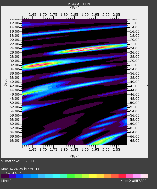
| Estimated Moho Depth: |
24.25 km |
| Estimated Crust Vp/Vs: |
1.89 |
| Assumed Crust Vp: |
6.483 km/s |
| Estimated Crust Vs: |
3.425 km/s |
| Estimated Crust Poisson's Ratio: |
0.31 |
|
| Radial Match: |
91.37003 % |
| Radial Bump: |
400 |
| Transverse Match: |
83.57605 % |
| Transverse Bump: |
400 |
| SOD ConfigId: |
110177 |
| Insert Time: |
2010-03-05 06:39:49.785 +0000 |
| GWidth: |
2.5 |
| Max Bumps: |
400 |
| Tol: |
0.001 |
|

Signal To Noise
| Channel | StoN | STA | LTA |
| US:AAM: :BHN:20040708T10:42:04.889004Z | 1.8938302 | 4.7092666E-7 | 2.486636E-7 |
| US:AAM: :BHE:20040708T10:42:04.889004Z | 0.9496404 | 2.519092E-7 | 2.65268E-7 |
| US:AAM: :BHZ:20040708T10:42:04.889004Z | 4.3986735 | 7.646231E-7 | 1.7383039E-7 |
| Arrivals |
| Ps | 3.4 SECOND |
| PpPs | 11 SECOND |
| PsPs/PpSs | 14 SECOND |


