You are here: Home > Network List > US - United States National Seismic Network Stations List
> Station AAM Ann Arbor, Michigan, USA > Earthquake Result Viewer
AAM Ann Arbor, Michigan, USA - Earthquake Result Viewer

| Earthquake location: |
Windward Islands |
| Earthquake latitude/longitude: |
15.0/-61.3 |
| Earthquake time(UTC): |
2007/11/29 (333) 19:00:19 GMT |
| Earthquake Depth: |
148 km |
| Earthquake Magnitude: |
6.9 MB, 7.4 MW, 7.4 MW |
| Earthquake Catalog/Contributor: |
WHDF/NEIC |
|
| Network: |
US United States National Seismic Network |
| Station: |
AAM Ann Arbor, Michigan, USA |
| Lat/Lon: |
42.30 N/83.66 W |
| Elevation: |
172 m |
|
| Distance: |
33.4 deg |
| Az: |
329.086 deg |
| Baz: |
137.986 deg |
| Ray Param: |
0.07778913 |
| Estimated Moho Depth: |
55.25 km |
| Estimated Crust Vp/Vs: |
1.72 |
| Assumed Crust Vp: |
6.483 km/s |
| Estimated Crust Vs: |
3.78 km/s |
| Estimated Crust Poisson's Ratio: |
0.24 |
|
| Radial Match: |
93.11711 % |
| Radial Bump: |
271 |
| Transverse Match: |
83.457466 % |
| Transverse Bump: |
400 |
| SOD ConfigId: |
2564 |
| Insert Time: |
2010-03-05 06:40:04.372 +0000 |
| GWidth: |
2.5 |
| Max Bumps: |
400 |
| Tol: |
0.001 |
|
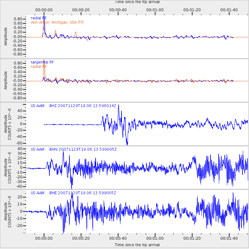
Signal To Noise
| Channel | StoN | STA | LTA |
| US:AAM: :BHN:20071129T19:06:13.599005Z | 16.546917 | 8.25026E-6 | 4.9859807E-7 |
| US:AAM: :BHE:20071129T19:06:13.599005Z | 12.662942 | 5.181377E-6 | 4.091764E-7 |
| US:AAM: :BHZ:20071129T19:06:13.596014Z | 29.506357 | 1.487051E-5 | 5.039765E-7 |
| Arrivals |
| Ps | 6.6 SECOND |
| PpPs | 21 SECOND |
| PsPs/PpSs | 28 SECOND |


