You are here: Home > Network List > TA - USArray Transportable Network (new EarthScope stations) Stations List
> Station D23K Nanushuk River, AK USA > Earthquake Result Viewer
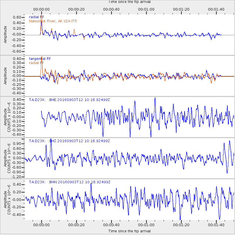
D23K Nanushuk River, AK USA - Earthquake Result Viewer
*The percent match for this event was below the threshold and hence no stack was calculated.
| Earthquake location: |
Oklahoma |
| Earthquake latitude/longitude: |
36.4/-96.9 |
| Earthquake time(UTC): |
2016/09/03 (247) 12:02:44 GMT |
| Earthquake Depth: |
5.4 km |
| Earthquake Magnitude: |
5.8 MWW, 5.6 MWB, 5.7 MWR, 5.8 MWC |
| Earthquake Catalog/Contributor: |
NEIC PDE/NEIC COMCAT |
|
| Network: |
TA USArray Transportable Network (new EarthScope stations) |
| Station: |
D23K Nanushuk River, AK USA |
| Lat/Lon: |
68.97 N/150.68 W |
| Elevation: |
406 m |
|
| Distance: |
43.7 deg |
| Az: |
335.052 deg |
| Baz: |
109.575 deg |
| Ray Param: |
$rayparam |
*The percent match for this event was below the threshold and hence was not used in the summary stack. |
|
| Radial Match: |
64.40705 % |
| Radial Bump: |
400 |
| Transverse Match: |
45.336502 % |
| Transverse Bump: |
400 |
| SOD ConfigId: |
11737051 |
| Insert Time: |
2019-04-25 10:47:12.628 +0000 |
| GWidth: |
2.5 |
| Max Bumps: |
400 |
| Tol: |
0.001 |
|
Signal To Noise
| Channel | StoN | STA | LTA |
| TA:D23K: :BHZ:20160903T12:10:18.92499Z | 3.247937 | 2.9735816E-7 | 9.155293E-8 |
| TA:D23K: :BHN:20160903T12:10:18.92499Z | 0.77419335 | 8.8006175E-8 | 1.1367467E-7 |
| TA:D23K: :BHE:20160903T12:10:18.92499Z | 1.2711943 | 9.784224E-8 | 7.696875E-8 |
| Arrivals |
| Ps | |
| PpPs | |
| PsPs/PpSs | |


