You are here: Home > Network List > TA - USArray Transportable Network (new EarthScope stations) Stations List
> Station E27K Coleen River, AK, USA > Earthquake Result Viewer
E27K Coleen River, AK, USA - Earthquake Result Viewer
| Earthquake location: |
Oklahoma |
| Earthquake latitude/longitude: |
36.4/-96.9 |
| Earthquake time(UTC): |
2016/09/03 (247) 12:02:44 GMT |
| Earthquake Depth: |
5.4 km |
| Earthquake Magnitude: |
5.8 MWW, 5.6 MWB, 5.7 MWR, 5.8 MWC |
| Earthquake Catalog/Contributor: |
NEIC PDE/NEIC COMCAT |
|
| Network: |
TA USArray Transportable Network (new EarthScope stations) |
| Station: |
E27K Coleen River, AK, USA |
| Lat/Lon: |
68.19 N/141.60 W |
| Elevation: |
654 m |
|
| Distance: |
40.3 deg |
| Az: |
336.028 deg |
| Baz: |
118.753 deg |
| Ray Param: |
0.074493185 |
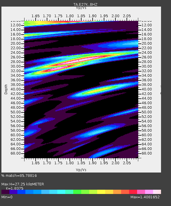
| Estimated Moho Depth: |
27.25 km |
| Estimated Crust Vp/Vs: |
1.84 |
| Assumed Crust Vp: |
6.522 km/s |
| Estimated Crust Vs: |
3.549 km/s |
| Estimated Crust Poisson's Ratio: |
0.29 |
|
| Radial Match: |
85.78816 % |
| Radial Bump: |
373 |
| Transverse Match: |
54.652454 % |
| Transverse Bump: |
400 |
| SOD ConfigId: |
11737051 |
| Insert Time: |
2019-04-25 10:47:16.589 +0000 |
| GWidth: |
2.5 |
| Max Bumps: |
400 |
| Tol: |
0.001 |
|

Signal To Noise
| Channel | StoN | STA | LTA |
| TA:E27K: :BHZ:20160903T12:09:51.500002Z | 5.3198338 | 4.4285304E-7 | 8.324565E-8 |
| TA:E27K: :BHN:20160903T12:09:51.500002Z | 1.2654043 | 1.1179319E-7 | 8.834583E-8 |
| TA:E27K: :BHE:20160903T12:09:51.500002Z | 2.4062393 | 1.5725831E-7 | 6.53544E-8 |
| Arrivals |
| Ps | 3.8 SECOND |
| PpPs | 11 SECOND |
| PsPs/PpSs | 15 SECOND |


