You are here: Home > Network List > TA - USArray Transportable Network (new EarthScope stations) Stations List
> Station G24K Hadweenzic River, AK, USA > Earthquake Result Viewer
G24K Hadweenzic River, AK, USA - Earthquake Result Viewer
| Earthquake location: |
Oklahoma |
| Earthquake latitude/longitude: |
36.4/-96.9 |
| Earthquake time(UTC): |
2016/09/03 (247) 12:02:44 GMT |
| Earthquake Depth: |
5.4 km |
| Earthquake Magnitude: |
5.8 MWW, 5.6 MWB, 5.7 MWR, 5.8 MWC |
| Earthquake Catalog/Contributor: |
NEIC PDE/NEIC COMCAT |
|
| Network: |
TA USArray Transportable Network (new EarthScope stations) |
| Station: |
G24K Hadweenzic River, AK, USA |
| Lat/Lon: |
66.70 N/147.48 W |
| Elevation: |
503 m |
|
| Distance: |
41.7 deg |
| Az: |
332.519 deg |
| Baz: |
110.678 deg |
| Ray Param: |
0.073622376 |
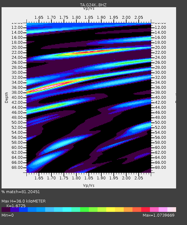
| Estimated Moho Depth: |
36.0 km |
| Estimated Crust Vp/Vs: |
1.67 |
| Assumed Crust Vp: |
6.522 km/s |
| Estimated Crust Vs: |
3.899 km/s |
| Estimated Crust Poisson's Ratio: |
0.22 |
|
| Radial Match: |
81.20451 % |
| Radial Bump: |
400 |
| Transverse Match: |
50.94781 % |
| Transverse Bump: |
400 |
| SOD ConfigId: |
11737051 |
| Insert Time: |
2019-04-25 10:47:31.104 +0000 |
| GWidth: |
2.5 |
| Max Bumps: |
400 |
| Tol: |
0.001 |
|

Signal To Noise
| Channel | StoN | STA | LTA |
| TA:G24K: :BHZ:20160903T12:10:03.325015Z | 5.5573435 | 4.661491E-7 | 8.387984E-8 |
| TA:G24K: :BHN:20160903T12:10:03.325015Z | 1.8548247 | 1.8061907E-7 | 9.737798E-8 |
| TA:G24K: :BHE:20160903T12:10:03.325015Z | 3.1583 | 2.6193683E-7 | 8.293602E-8 |
| Arrivals |
| Ps | 4.0 SECOND |
| PpPs | 14 SECOND |
| PsPs/PpSs | 18 SECOND |


