You are here: Home > Network List > TA - USArray Transportable Network (new EarthScope stations) Stations List
> Station H24K Noodor Dome, AK, USA > Earthquake Result Viewer
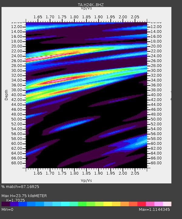
H24K Noodor Dome, AK, USA - Earthquake Result Viewer
| Earthquake location: |
Oklahoma |
| Earthquake latitude/longitude: |
36.4/-96.9 |
| Earthquake time(UTC): |
2016/09/03 (247) 12:02:44 GMT |
| Earthquake Depth: |
5.4 km |
| Earthquake Magnitude: |
5.8 MWW, 5.6 MWB, 5.7 MWR, 5.8 MWC |
| Earthquake Catalog/Contributor: |
NEIC PDE/NEIC COMCAT |
|
| Network: |
TA USArray Transportable Network (new EarthScope stations) |
| Station: |
H24K Noodor Dome, AK, USA |
| Lat/Lon: |
65.84 N/147.88 W |
| Elevation: |
814 m |
|
| Distance: |
41.6 deg |
| Az: |
331.209 deg |
| Baz: |
109.331 deg |
| Ray Param: |
0.07371333 |
| Estimated Moho Depth: |
23.75 km |
| Estimated Crust Vp/Vs: |
1.70 |
| Assumed Crust Vp: |
6.566 km/s |
| Estimated Crust Vs: |
3.857 km/s |
| Estimated Crust Poisson's Ratio: |
0.24 |
|
| Radial Match: |
87.16925 % |
| Radial Bump: |
400 |
| Transverse Match: |
76.43968 % |
| Transverse Bump: |
400 |
| SOD ConfigId: |
11737051 |
| Insert Time: |
2019-04-25 10:47:36.787 +0000 |
| GWidth: |
2.5 |
| Max Bumps: |
400 |
| Tol: |
0.001 |
|

Signal To Noise
| Channel | StoN | STA | LTA |
| TA:H24K: :BHZ:20160903T12:10:02.149996Z | 8.823592 | 5.5168704E-7 | 6.252409E-8 |
| TA:H24K: :BHN:20160903T12:10:02.149996Z | 1.0394539 | 8.9711904E-8 | 8.630677E-8 |
| TA:H24K: :BHE:20160903T12:10:02.149996Z | 3.6277757 | 2.4637498E-7 | 6.791351E-8 |
| Arrivals |
| Ps | 2.7 SECOND |
| PpPs | 9.1 SECOND |
| PsPs/PpSs | 12 SECOND |


