You are here: Home > Network List > US - United States National Seismic Network Stations List
> Station AGMN Agassiz National Wildlife Refuge, Minnesota, USA > Earthquake Result Viewer
AGMN Agassiz National Wildlife Refuge, Minnesota, USA - Earthquake Result Viewer
| Earthquake location: |
Near Coast Of Central Chile |
| Earthquake latitude/longitude: |
-31.7/-71.6 |
| Earthquake time(UTC): |
2015/09/21 (264) 17:39:58 GMT |
| Earthquake Depth: |
25 km |
| Earthquake Magnitude: |
6.5 MB, 6.5 MI, 6.6 MWW |
| Earthquake Catalog/Contributor: |
NEIC PDE/NEIC COMCAT |
|
| Network: |
US United States National Seismic Network |
| Station: |
AGMN Agassiz National Wildlife Refuge, Minnesota, USA |
| Lat/Lon: |
48.30 N/95.86 W |
| Elevation: |
351 m |
|
| Distance: |
82.6 deg |
| Az: |
343.959 deg |
| Baz: |
159.356 deg |
| Ray Param: |
0.046759553 |
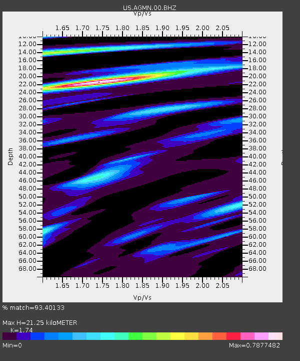
| Estimated Moho Depth: |
21.25 km |
| Estimated Crust Vp/Vs: |
1.74 |
| Assumed Crust Vp: |
6.419 km/s |
| Estimated Crust Vs: |
3.689 km/s |
| Estimated Crust Poisson's Ratio: |
0.25 |
|
| Radial Match: |
93.40133 % |
| Radial Bump: |
313 |
| Transverse Match: |
81.526855 % |
| Transverse Bump: |
400 |
| SOD ConfigId: |
1156111 |
| Insert Time: |
2015-10-05 18:00:13.069 +0000 |
| GWidth: |
2.5 |
| Max Bumps: |
400 |
| Tol: |
0.001 |
|

Signal To Noise
| Channel | StoN | STA | LTA |
| US:AGMN:00:BHZ:20150921T17:51:48.50001Z | 27.699364 | 4.2809093E-6 | 1.5454901E-7 |
| US:AGMN:00:BH1:20150921T17:51:48.50001Z | 11.221861 | 1.4184127E-6 | 1.2639728E-7 |
| US:AGMN:00:BH2:20150921T17:51:48.50001Z | 2.7796822 | 5.686464E-7 | 2.0457246E-7 |
| Arrivals |
| Ps | 2.5 SECOND |
| PpPs | 8.8 SECOND |
| PsPs/PpSs | 11 SECOND |


