You are here: Home > Network List > TA - USArray Transportable Network (new EarthScope stations) Stations List
> Station J26L Joseph Creek, AK, USA > Earthquake Result Viewer
J26L Joseph Creek, AK, USA - Earthquake Result Viewer
*The percent match for this event was below the threshold and hence no stack was calculated.
| Earthquake location: |
Mariana Islands Region |
| Earthquake latitude/longitude: |
20.3/147.4 |
| Earthquake time(UTC): |
2016/09/03 (247) 14:04:47 GMT |
| Earthquake Depth: |
10 km |
| Earthquake Magnitude: |
5.5 MB |
| Earthquake Catalog/Contributor: |
NEIC PDE/NEIC COMCAT |
|
| Network: |
TA USArray Transportable Network (new EarthScope stations) |
| Station: |
J26L Joseph Creek, AK, USA |
| Lat/Lon: |
64.50 N/143.56 W |
| Elevation: |
1144 m |
|
| Distance: |
62.9 deg |
| Az: |
27.012 deg |
| Baz: |
260.065 deg |
| Ray Param: |
$rayparam |
*The percent match for this event was below the threshold and hence was not used in the summary stack. |
|
| Radial Match: |
63.083412 % |
| Radial Bump: |
400 |
| Transverse Match: |
59.187637 % |
| Transverse Bump: |
400 |
| SOD ConfigId: |
11737051 |
| Insert Time: |
2019-04-25 10:53:54.598 +0000 |
| GWidth: |
2.5 |
| Max Bumps: |
400 |
| Tol: |
0.001 |
|
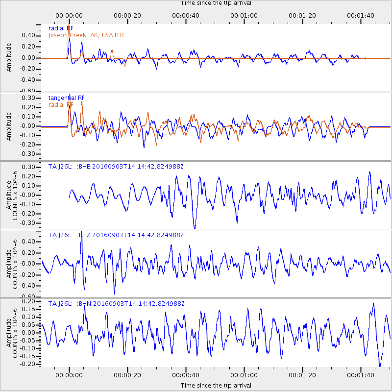
Signal To Noise
| Channel | StoN | STA | LTA |
| TA:J26L: :BHZ:20160903T14:14:42.824988Z | 2.2485147 | 1.9101451E-7 | 8.495142E-8 |
| TA:J26L: :BHN:20160903T14:14:42.824988Z | 0.56320035 | 4.03694E-8 | 7.1678585E-8 |
| TA:J26L: :BHE:20160903T14:14:42.824988Z | 1.1167302 | 7.4222434E-8 | 6.6464075E-8 |
| Arrivals |
| Ps | |
| PpPs | |
| PsPs/PpSs | |


