You are here: Home > Network List > US - United States National Seismic Network Stations List
> Station AAM Ann Arbor, Michigan, USA > Earthquake Result Viewer
AAM Ann Arbor, Michigan, USA - Earthquake Result Viewer

| Earthquake location: |
Western Iran |
| Earthquake latitude/longitude: |
35.6/49.0 |
| Earthquake time(UTC): |
2002/06/22 (173) 02:58:21 GMT |
| Earthquake Depth: |
10 km |
| Earthquake Magnitude: |
6.2 MB, 6.4 MS, 6.5 MW, 6.5 MW |
| Earthquake Catalog/Contributor: |
WHDF/NEIC |
|
| Network: |
US United States National Seismic Network |
| Station: |
AAM Ann Arbor, Michigan, USA |
| Lat/Lon: |
42.30 N/83.66 W |
| Elevation: |
172 m |
|
| Distance: |
91.2 deg |
| Az: |
326.955 deg |
| Baz: |
36.785 deg |
| Ray Param: |
0.04161863 |
| Estimated Moho Depth: |
29.5 km |
| Estimated Crust Vp/Vs: |
1.84 |
| Assumed Crust Vp: |
6.483 km/s |
| Estimated Crust Vs: |
3.523 km/s |
| Estimated Crust Poisson's Ratio: |
0.29 |
|
| Radial Match: |
93.65737 % |
| Radial Bump: |
400 |
| Transverse Match: |
82.79771 % |
| Transverse Bump: |
400 |
| SOD ConfigId: |
110177 |
| Insert Time: |
2010-03-05 06:41:39.536 +0000 |
| GWidth: |
2.5 |
| Max Bumps: |
400 |
| Tol: |
0.001 |
|
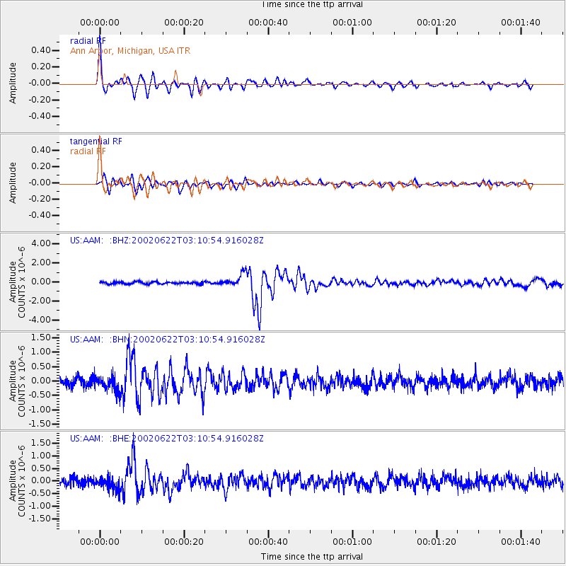
Signal To Noise
| Channel | StoN | STA | LTA |
| US:AAM: :BHN:20020622T03:10:54.916028Z | 1.9663098 | 2.6651708E-7 | 1.3554177E-7 |
| US:AAM: :BHE:20020622T03:10:54.916028Z | 1.9372118 | 2.6355107E-7 | 1.3604661E-7 |
| US:AAM: :BHZ:20020622T03:10:54.916028Z | 6.077736 | 7.026035E-7 | 1.1560283E-7 |
| Arrivals |
| Ps | 3.9 SECOND |
| PpPs | 13 SECOND |
| PsPs/PpSs | 17 SECOND |


