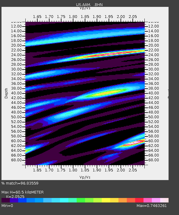
AAM Ann Arbor, Michigan, USA - Earthquake Result Viewer

Earthquake location: Rat Islands, Aleutian Islands
Earthquake latitude/longitude: 51.4/176.8
Earthquake time(UTC): 2003/06/23 (174) 12:12:34 GMT
Earthquake Depth: 20 km
Earthquake Magnitude: 6.3 MB, 7.0 MS, 6.9 MW, 6.8 MW
Earthquake Catalog/Contributor: WHDF/NEIC
Network: US United States National Seismic Network
Station: AAM Ann Arbor, Michigan, USA
Lat/Lon: 42.30 N/83.66 W
Elevation: 172 m
Distance: 63.5 deg
Az: 54.814 deg
Baz: 316.406 deg
Ray Param: 0.059500623
Estimated Moho Depth: 60.5 km
Estimated Crust Vp/Vs: 2.05
Assumed Crust Vp: 6.483 km/s
Estimated Crust Vs: 3.158 km/s
Estimated Crust Poisson's Ratio: 0.34
Radial Match: 96.83559 %
Radial Bump: 369
Transverse Match: 90.93847 %
Transverse Bump: 400
SOD ConfigId: 110177
Insert Time: 2010-03-05 06:42:04.381 +0000
GWidth: 2.5
Max Bumps: 400
Tol: 0.001

Signal To Noise

ChannelStoNSTALTA
US:AAM: :BHN:20030623T12:22:32.207Z1.41707425.988169E-74.225727E-7
US:AAM: :BHE:20030623T12:22:32.207Z1.07509494.966346E-74.6194484E-7
US:AAM: :BHZ:20030623T12:22:32.207Z2.69050079.616049E-73.574074E-7
Arrivals
Ps10 SECOND
PpPs27 SECOND
PsPs/PpSs38 SECOND