You are here: Home > Network List > AV - Alaska Volcano Observatory Stations List
> Station SPCR Ckakachatna River, Mount Spurr, Alaska > Earthquake Result Viewer
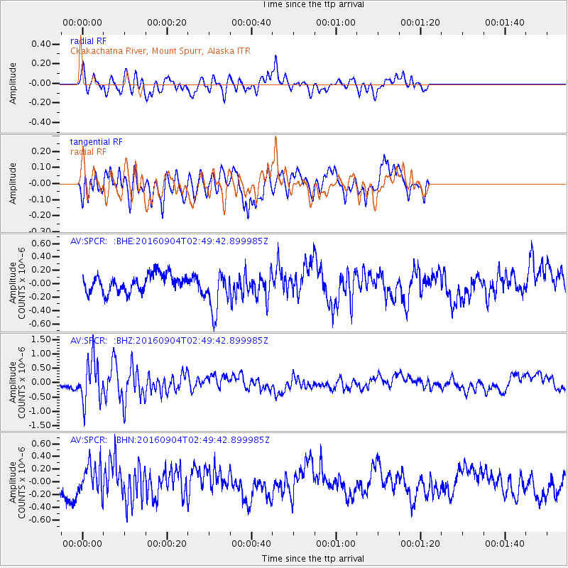
SPCR Ckakachatna River, Mount Spurr, Alaska - Earthquake Result Viewer
*The percent match for this event was below the threshold and hence no stack was calculated.
| Earthquake location: |
Mindanao, Philippines |
| Earthquake latitude/longitude: |
8.4/125.9 |
| Earthquake time(UTC): |
2016/09/04 (248) 02:38:12 GMT |
| Earthquake Depth: |
12 km |
| Earthquake Magnitude: |
5.9 MWP |
| Earthquake Catalog/Contributor: |
NEIC PDE/NEIC COMCAT |
|
| Network: |
AV Alaska Volcano Observatory |
| Station: |
SPCR Ckakachatna River, Mount Spurr, Alaska |
| Lat/Lon: |
61.20 N/152.21 W |
| Elevation: |
984 m |
|
| Distance: |
78.8 deg |
| Az: |
29.255 deg |
| Baz: |
266.95 deg |
| Ray Param: |
$rayparam |
*The percent match for this event was below the threshold and hence was not used in the summary stack. |
|
| Radial Match: |
62.1496 % |
| Radial Bump: |
400 |
| Transverse Match: |
53.19078 % |
| Transverse Bump: |
400 |
| SOD ConfigId: |
11737051 |
| Insert Time: |
2019-04-25 10:58:24.619 +0000 |
| GWidth: |
2.5 |
| Max Bumps: |
400 |
| Tol: |
0.001 |
|
Signal To Noise
| Channel | StoN | STA | LTA |
| AV:SPCR: :BHZ:20160904T02:49:42.899985Z | 7.9531107 | 7.380574E-7 | 9.2801095E-8 |
| AV:SPCR: :BHN:20160904T02:49:42.899985Z | 1.3310713 | 2.3608798E-7 | 1.773669E-7 |
| AV:SPCR: :BHE:20160904T02:49:42.899985Z | 2.4874938 | 3.2099862E-7 | 1.2904499E-7 |
| Arrivals |
| Ps | |
| PpPs | |
| PsPs/PpSs | |


