You are here: Home > Network List > TA - USArray Transportable Network (new EarthScope stations) Stations List
> Station O19K Port Alsworth, AK, USA > Earthquake Result Viewer
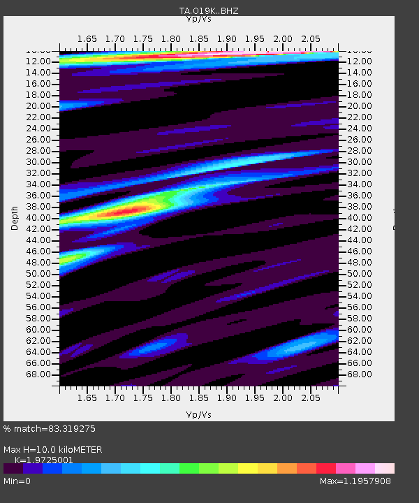
O19K Port Alsworth, AK, USA - Earthquake Result Viewer
| Earthquake location: |
Mindanao, Philippines |
| Earthquake latitude/longitude: |
8.4/125.9 |
| Earthquake time(UTC): |
2016/09/04 (248) 02:38:12 GMT |
| Earthquake Depth: |
12 km |
| Earthquake Magnitude: |
5.9 MWP |
| Earthquake Catalog/Contributor: |
NEIC PDE/NEIC COMCAT |
|
| Network: |
TA USArray Transportable Network (new EarthScope stations) |
| Station: |
O19K Port Alsworth, AK, USA |
| Lat/Lon: |
60.20 N/154.32 W |
| Elevation: |
96 m |
|
| Distance: |
77.7 deg |
| Az: |
30.211 deg |
| Baz: |
265.307 deg |
| Ray Param: |
0.05014945 |
| Estimated Moho Depth: |
10.0 km |
| Estimated Crust Vp/Vs: |
1.97 |
| Assumed Crust Vp: |
6.566 km/s |
| Estimated Crust Vs: |
3.329 km/s |
| Estimated Crust Poisson's Ratio: |
0.33 |
|
| Radial Match: |
83.319275 % |
| Radial Bump: |
400 |
| Transverse Match: |
70.09004 % |
| Transverse Bump: |
400 |
| SOD ConfigId: |
11737051 |
| Insert Time: |
2019-04-25 11:01:43.639 +0000 |
| GWidth: |
2.5 |
| Max Bumps: |
400 |
| Tol: |
0.001 |
|

Signal To Noise
| Channel | StoN | STA | LTA |
| TA:O19K: :BHZ:20160904T02:49:36.824973Z | 5.1340213 | 6.5733894E-7 | 1.2803588E-7 |
| TA:O19K: :BHN:20160904T02:49:36.824973Z | 1.1689004 | 1.60728E-7 | 1.375036E-7 |
| TA:O19K: :BHE:20160904T02:49:36.824973Z | 2.7856636 | 2.6250348E-7 | 9.4233734E-8 |
| Arrivals |
| Ps | 1.5 SECOND |
| PpPs | 4.4 SECOND |
| PsPs/PpSs | 5.9 SECOND |


