You are here: Home > Network List > NN - Western Great Basin/Eastern Sierra Nevada Stations List
> Station OMMB Old Mammoth Mine, surface, wgs-84 > Earthquake Result Viewer
OMMB Old Mammoth Mine, surface, wgs-84 - Earthquake Result Viewer
| Earthquake location: |
Komandorskiye Ostrova Region |
| Earthquake latitude/longitude: |
54.3/168.6 |
| Earthquake time(UTC): |
2016/09/05 (249) 22:54:04 GMT |
| Earthquake Depth: |
10 km |
| Earthquake Magnitude: |
5.7 MB |
| Earthquake Catalog/Contributor: |
NEIC PDE/NEIC COMCAT |
|
| Network: |
NN Western Great Basin/Eastern Sierra Nevada |
| Station: |
OMMB Old Mammoth Mine, surface, wgs-84 |
| Lat/Lon: |
37.61 N/119.00 W |
| Elevation: |
2768 m |
|
| Distance: |
50.7 deg |
| Az: |
77.977 deg |
| Baz: |
313.855 deg |
| Ray Param: |
0.06787278 |
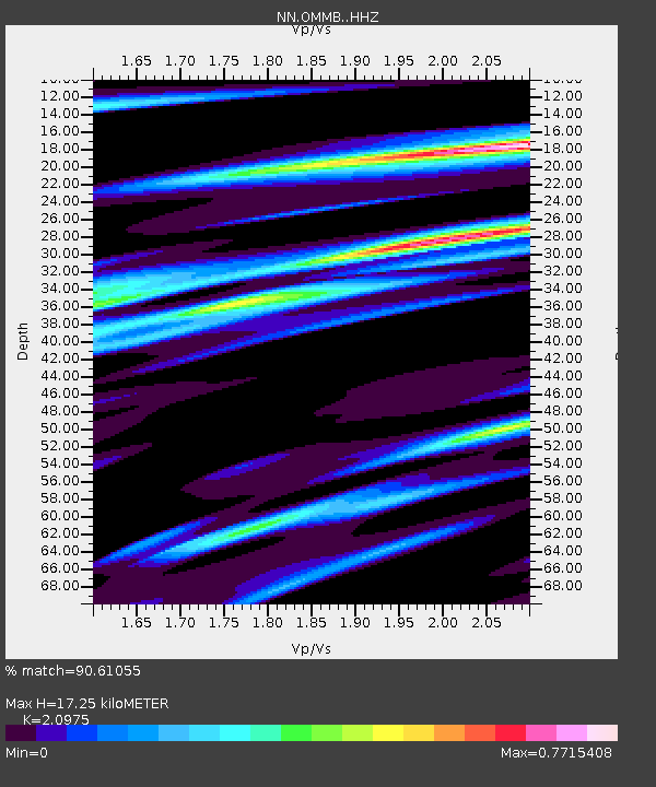
| Estimated Moho Depth: |
17.25 km |
| Estimated Crust Vp/Vs: |
2.10 |
| Assumed Crust Vp: |
6.291 km/s |
| Estimated Crust Vs: |
2.999 km/s |
| Estimated Crust Poisson's Ratio: |
0.35 |
|
| Radial Match: |
90.61055 % |
| Radial Bump: |
320 |
| Transverse Match: |
80.886925 % |
| Transverse Bump: |
391 |
| SOD ConfigId: |
11737051 |
| Insert Time: |
2019-04-25 11:13:44.222 +0000 |
| GWidth: |
2.5 |
| Max Bumps: |
400 |
| Tol: |
0.001 |
|

Signal To Noise
| Channel | StoN | STA | LTA |
| NN:OMMB: :HHZ:20160905T23:02:33.11499Z | 2.5576196 | 2.0703557E-7 | 8.094854E-8 |
| NN:OMMB: :HHN:20160905T23:02:33.11499Z | 1.4147714 | 1.2257986E-7 | 8.664288E-8 |
| NN:OMMB: :HHE:20160905T23:02:33.11499Z | 1.1843634 | 9.628846E-8 | 8.129977E-8 |
| Arrivals |
| Ps | 3.2 SECOND |
| PpPs | 8.1 SECOND |
| PsPs/PpSs | 11 SECOND |


