You are here: Home > Network List > TA - USArray Transportable Network (new EarthScope stations) Stations List
> Station TPFO Pinon Flats, CA, USA > Earthquake Result Viewer
TPFO Pinon Flats, CA, USA - Earthquake Result Viewer
| Earthquake location: |
Komandorskiye Ostrova Region |
| Earthquake latitude/longitude: |
54.3/168.6 |
| Earthquake time(UTC): |
2016/09/05 (249) 22:54:04 GMT |
| Earthquake Depth: |
10 km |
| Earthquake Magnitude: |
5.7 MB |
| Earthquake Catalog/Contributor: |
NEIC PDE/NEIC COMCAT |
|
| Network: |
TA USArray Transportable Network (new EarthScope stations) |
| Station: |
TPFO Pinon Flats, CA, USA |
| Lat/Lon: |
33.61 N/116.45 W |
| Elevation: |
1275 m |
|
| Distance: |
55.0 deg |
| Az: |
79.673 deg |
| Baz: |
316.357 deg |
| Ray Param: |
0.0650789 |
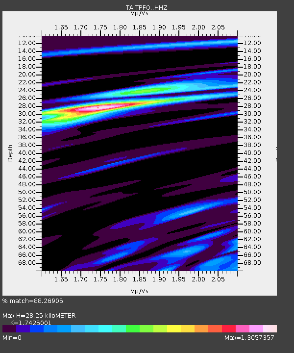
| Estimated Moho Depth: |
28.25 km |
| Estimated Crust Vp/Vs: |
1.74 |
| Assumed Crust Vp: |
6.264 km/s |
| Estimated Crust Vs: |
3.595 km/s |
| Estimated Crust Poisson's Ratio: |
0.25 |
|
| Radial Match: |
88.26905 % |
| Radial Bump: |
400 |
| Transverse Match: |
76.03044 % |
| Transverse Bump: |
346 |
| SOD ConfigId: |
11737051 |
| Insert Time: |
2019-04-25 11:16:17.309 +0000 |
| GWidth: |
2.5 |
| Max Bumps: |
400 |
| Tol: |
0.001 |
|
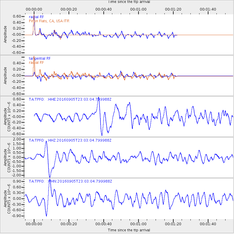
Signal To Noise
| Channel | StoN | STA | LTA |
| TA:TPFO: :HHZ:20160905T23:03:04.799988Z | 3.1656039 | 2.90244E-7 | 9.168677E-8 |
| TA:TPFO: :HHN:20160905T23:03:04.799988Z | 2.1495674 | 1.7710627E-7 | 8.239159E-8 |
| TA:TPFO: :HHE:20160905T23:03:04.799988Z | 0.89406025 | 8.203155E-8 | 9.17517E-8 |
| Arrivals |
| Ps | 3.5 SECOND |
| PpPs | 12 SECOND |
| PsPs/PpSs | 15 SECOND |


