You are here: Home > Network List > TJ - Tajikistan National Seismic Network Stations List
> Station IGRN Igron, Tajikistan > Earthquake Result Viewer
IGRN Igron, Tajikistan - Earthquake Result Viewer
| Earthquake location: |
Komandorskiye Ostrova Region |
| Earthquake latitude/longitude: |
54.3/168.6 |
| Earthquake time(UTC): |
2016/09/05 (249) 22:54:04 GMT |
| Earthquake Depth: |
10 km |
| Earthquake Magnitude: |
5.7 MB |
| Earthquake Catalog/Contributor: |
NEIC PDE/NEIC COMCAT |
|
| Network: |
TJ Tajikistan National Seismic Network |
| Station: |
IGRN Igron, Tajikistan |
| Lat/Lon: |
38.22 N/69.33 E |
| Elevation: |
1284 m |
|
| Distance: |
64.8 deg |
| Az: |
300.809 deg |
| Baz: |
39.674 deg |
| Ray Param: |
0.05866638 |
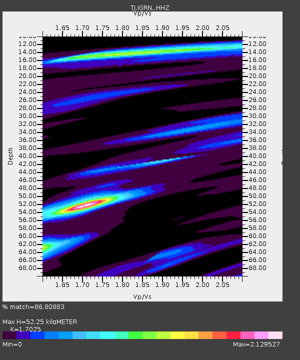
| Estimated Moho Depth: |
52.25 km |
| Estimated Crust Vp/Vs: |
1.70 |
| Assumed Crust Vp: |
6.483 km/s |
| Estimated Crust Vs: |
3.808 km/s |
| Estimated Crust Poisson's Ratio: |
0.24 |
|
| Radial Match: |
86.80883 % |
| Radial Bump: |
339 |
| Transverse Match: |
61.640285 % |
| Transverse Bump: |
400 |
| SOD ConfigId: |
11737051 |
| Insert Time: |
2019-04-25 11:16:30.571 +0000 |
| GWidth: |
2.5 |
| Max Bumps: |
400 |
| Tol: |
0.001 |
|

Signal To Noise
| Channel | StoN | STA | LTA |
| TJ:IGRN: :HHZ:20160905T23:04:11.679993Z | 25.942661 | 3.0389817E-6 | 1.1714226E-7 |
| TJ:IGRN: :HHN:20160905T23:04:11.679993Z | 4.4321213 | 8.5667455E-7 | 1.9328772E-7 |
| TJ:IGRN: :HHE:20160905T23:04:11.679993Z | 4.571941 | 5.807787E-7 | 1.2703111E-7 |
| Arrivals |
| Ps | 5.9 SECOND |
| PpPs | 21 SECOND |
| PsPs/PpSs | 27 SECOND |


