You are here: Home > Network List > X416 - Monitoring Active Faults for Tectonic Mapping Efforts in Washington State Stations List
> Station MA02 King County, WA, USA > Earthquake Result Viewer
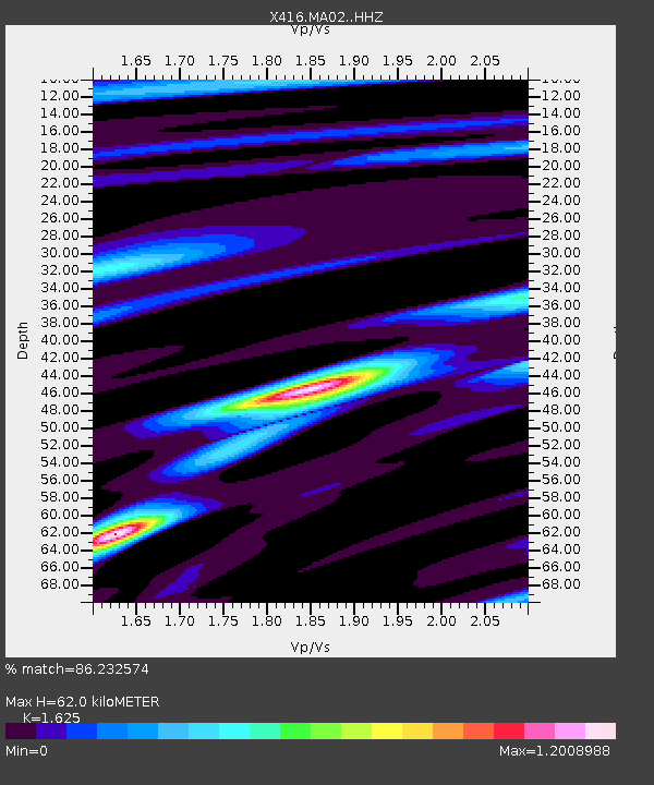
MA02 King County, WA, USA - Earthquake Result Viewer
| Earthquake location: |
Komandorskiye Ostrova Region |
| Earthquake latitude/longitude: |
54.3/168.6 |
| Earthquake time(UTC): |
2016/09/05 (249) 22:54:04 GMT |
| Earthquake Depth: |
10 km |
| Earthquake Magnitude: |
5.7 MB |
| Earthquake Catalog/Contributor: |
NEIC PDE/NEIC COMCAT |
|
| Network: |
X4 Monitoring Active Faults for Tectonic Mapping Efforts in Washington State |
| Station: |
MA02 King County, WA, USA |
| Lat/Lon: |
47.72 N/121.83 W |
| Elevation: |
-1.0 m |
|
| Distance: |
42.6 deg |
| Az: |
69.16 deg |
| Baz: |
305.865 deg |
| Ray Param: |
0.07307365 |
| Estimated Moho Depth: |
62.0 km |
| Estimated Crust Vp/Vs: |
1.62 |
| Assumed Crust Vp: |
6.597 km/s |
| Estimated Crust Vs: |
4.06 km/s |
| Estimated Crust Poisson's Ratio: |
0.20 |
|
| Radial Match: |
86.232574 % |
| Radial Bump: |
400 |
| Transverse Match: |
83.1534 % |
| Transverse Bump: |
400 |
| SOD ConfigId: |
11737051 |
| Insert Time: |
2019-04-25 11:17:25.927 +0000 |
| GWidth: |
2.5 |
| Max Bumps: |
400 |
| Tol: |
0.001 |
|

Signal To Noise
| Channel | StoN | STA | LTA |
| X4:MA02: :HHZ:20160905T23:01:29.674988Z | 4.5051517 | 2.6785807E-7 | 5.9455953E-8 |
| X4:MA02: :HHN:20160905T23:01:29.674988Z | 0.98347163 | 8.750112E-8 | 8.8971674E-8 |
| X4:MA02: :HHE:20160905T23:01:29.674988Z | 3.6310441 | 2.3505325E-7 | 6.473434E-8 |
| Arrivals |
| Ps | 6.4 SECOND |
| PpPs | 23 SECOND |
| PsPs/PpSs | 29 SECOND |


