You are here: Home > Network List > TA - USArray Transportable Network (new EarthScope stations) Stations List
> Station G21K Allakaket, AK, USA > Earthquake Result Viewer
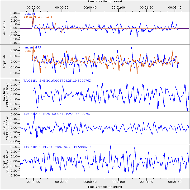
G21K Allakaket, AK, USA - Earthquake Result Viewer
*The percent match for this event was below the threshold and hence no stack was calculated.
| Earthquake location: |
Santa Cruz Islands |
| Earthquake latitude/longitude: |
-11.0/166.0 |
| Earthquake time(UTC): |
2016/09/06 (250) 04:13:35 GMT |
| Earthquake Depth: |
73 km |
| Earthquake Magnitude: |
5.8 MB |
| Earthquake Catalog/Contributor: |
NEIC PDE/NEIC ALERT |
|
| Network: |
TA USArray Transportable Network (new EarthScope stations) |
| Station: |
G21K Allakaket, AK, USA |
| Lat/Lon: |
66.52 N/153.51 W |
| Elevation: |
446 m |
|
| Distance: |
82.8 deg |
| Az: |
15.212 deg |
| Baz: |
220.013 deg |
| Ray Param: |
$rayparam |
*The percent match for this event was below the threshold and hence was not used in the summary stack. |
|
| Radial Match: |
59.506157 % |
| Radial Bump: |
400 |
| Transverse Match: |
50.38477 % |
| Transverse Bump: |
400 |
| SOD ConfigId: |
11737051 |
| Insert Time: |
2019-04-25 11:23:21.707 +0000 |
| GWidth: |
2.5 |
| Max Bumps: |
400 |
| Tol: |
0.001 |
|
Signal To Noise
| Channel | StoN | STA | LTA |
| TA:G21K: :BHZ:20160906T04:25:19.599976Z | 3.0814655 | 2.6682608E-7 | 8.6590646E-8 |
| TA:G21K: :BHN:20160906T04:25:19.599976Z | 0.47238243 | 6.413225E-8 | 1.3576341E-7 |
| TA:G21K: :BHE:20160906T04:25:19.599976Z | 0.37879324 | 3.8316905E-8 | 1.011552E-7 |
| Arrivals |
| Ps | |
| PpPs | |
| PsPs/PpSs | |


