You are here: Home > Network List > TA - USArray Transportable Network (new EarthScope stations) Stations List
> Station J26L Joseph Creek, AK, USA > Earthquake Result Viewer
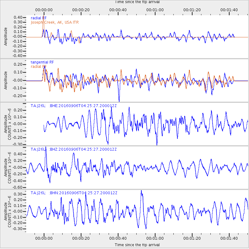
J26L Joseph Creek, AK, USA - Earthquake Result Viewer
*The percent match for this event was below the threshold and hence no stack was calculated.
| Earthquake location: |
Santa Cruz Islands |
| Earthquake latitude/longitude: |
-11.0/166.0 |
| Earthquake time(UTC): |
2016/09/06 (250) 04:13:35 GMT |
| Earthquake Depth: |
73 km |
| Earthquake Magnitude: |
5.8 MB |
| Earthquake Catalog/Contributor: |
NEIC PDE/NEIC ALERT |
|
| Network: |
TA USArray Transportable Network (new EarthScope stations) |
| Station: |
J26L Joseph Creek, AK, USA |
| Lat/Lon: |
64.50 N/143.56 W |
| Elevation: |
1144 m |
|
| Distance: |
84.2 deg |
| Az: |
19.599 deg |
| Baz: |
229.553 deg |
| Ray Param: |
$rayparam |
*The percent match for this event was below the threshold and hence was not used in the summary stack. |
|
| Radial Match: |
53.971813 % |
| Radial Bump: |
400 |
| Transverse Match: |
38.558067 % |
| Transverse Bump: |
392 |
| SOD ConfigId: |
11737051 |
| Insert Time: |
2019-04-25 11:23:33.919 +0000 |
| GWidth: |
2.5 |
| Max Bumps: |
400 |
| Tol: |
0.001 |
|
Signal To Noise
| Channel | StoN | STA | LTA |
| TA:J26L: :BHZ:20160906T04:25:27.200012Z | 2.3035924 | 2.5677303E-7 | 1.1146635E-7 |
| TA:J26L: :BHN:20160906T04:25:27.200012Z | 0.891449 | 7.843297E-8 | 8.7983686E-8 |
| TA:J26L: :BHE:20160906T04:25:27.200012Z | 2.2465098 | 1.6606579E-7 | 7.392168E-8 |
| Arrivals |
| Ps | |
| PpPs | |
| PsPs/PpSs | |


