You are here: Home > Network List > UW - Pacific Northwest Regional Seismic Network Stations List
> Station LEBA Lebam, WA, USA > Earthquake Result Viewer
LEBA Lebam, WA, USA - Earthquake Result Viewer
*The percent match for this event was below the threshold and hence no stack was calculated.
| Earthquake location: |
Santa Cruz Islands |
| Earthquake latitude/longitude: |
-11.0/166.0 |
| Earthquake time(UTC): |
2016/09/06 (250) 04:13:35 GMT |
| Earthquake Depth: |
73 km |
| Earthquake Magnitude: |
5.8 MB |
| Earthquake Catalog/Contributor: |
NEIC PDE/NEIC ALERT |
|
| Network: |
UW Pacific Northwest Regional Seismic Network |
| Station: |
LEBA Lebam, WA, USA |
| Lat/Lon: |
46.55 N/123.56 W |
| Elevation: |
73 m |
|
| Distance: |
84.8 deg |
| Az: |
40.773 deg |
| Baz: |
248.304 deg |
| Ray Param: |
$rayparam |
*The percent match for this event was below the threshold and hence was not used in the summary stack. |
|
| Radial Match: |
54.392605 % |
| Radial Bump: |
400 |
| Transverse Match: |
53.079502 % |
| Transverse Bump: |
400 |
| SOD ConfigId: |
11737051 |
| Insert Time: |
2019-04-25 11:24:21.511 +0000 |
| GWidth: |
2.5 |
| Max Bumps: |
400 |
| Tol: |
0.001 |
|
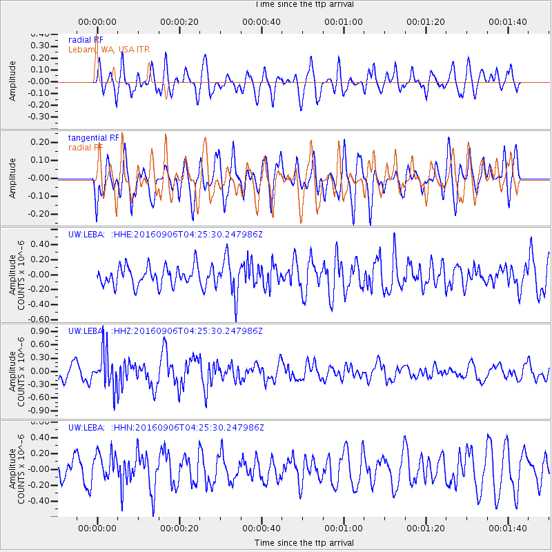
Signal To Noise
| Channel | StoN | STA | LTA |
| UW:LEBA: :HHZ:20160906T04:25:30.247986Z | 2.268883 | 4.082779E-7 | 1.7994667E-7 |
| UW:LEBA: :HHN:20160906T04:25:30.247986Z | 1.3497543 | 1.8631442E-7 | 1.380358E-7 |
| UW:LEBA: :HHE:20160906T04:25:30.247986Z | 2.0048485 | 2.4698983E-7 | 1.2319626E-7 |
| Arrivals |
| Ps | |
| PpPs | |
| PsPs/PpSs | |


