You are here: Home > Network List > CB - China National Seismic Network Stations List
> Station GYA Guiyang,Yunnan Province > Earthquake Result Viewer
GYA Guiyang,Yunnan Province - Earthquake Result Viewer
| Earthquake location: |
Macquarie Island Region |
| Earthquake latitude/longitude: |
-54.7/158.6 |
| Earthquake time(UTC): |
2016/09/08 (252) 21:46:19 GMT |
| Earthquake Depth: |
10 km |
| Earthquake Magnitude: |
6.3 MWP, 6.7 MI |
| Earthquake Catalog/Contributor: |
NEIC PDE/NEIC COMCAT |
|
| Network: |
CB China National Seismic Network |
| Station: |
GYA Guiyang,Yunnan Province |
| Lat/Lon: |
26.46 N/106.66 E |
| Elevation: |
1162 m |
|
| Distance: |
92.3 deg |
| Az: |
315.058 deg |
| Baz: |
152.753 deg |
| Ray Param: |
0.04148348 |
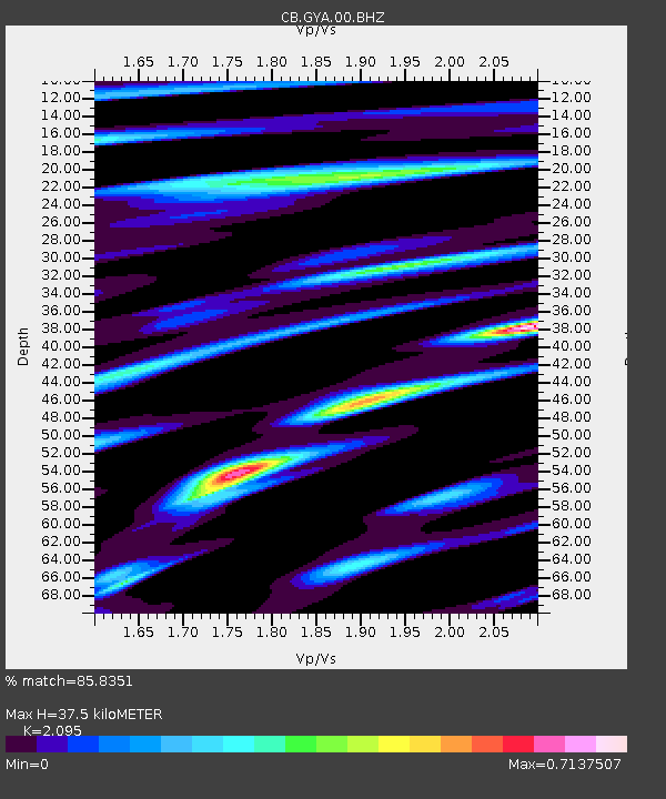
| Estimated Moho Depth: |
37.5 km |
| Estimated Crust Vp/Vs: |
2.10 |
| Assumed Crust Vp: |
6.113 km/s |
| Estimated Crust Vs: |
2.918 km/s |
| Estimated Crust Poisson's Ratio: |
0.35 |
|
| Radial Match: |
85.8351 % |
| Radial Bump: |
392 |
| Transverse Match: |
74.1991 % |
| Transverse Bump: |
400 |
| SOD ConfigId: |
11737051 |
| Insert Time: |
2019-04-25 11:26:39.989 +0000 |
| GWidth: |
2.5 |
| Max Bumps: |
400 |
| Tol: |
0.001 |
|

Signal To Noise
| Channel | StoN | STA | LTA |
| CB:GYA:00:BHZ:20160908T21:58:58.660Z | 6.2577715 | 4.7547002E-7 | 7.598073E-8 |
| CB:GYA:00:BHN:20160908T21:58:58.660Z | 1.74494 | 1.244274E-7 | 7.1307554E-8 |
| CB:GYA:00:BHE:20160908T21:58:58.660Z | 1.4638978 | 9.697434E-8 | 6.624393E-8 |
| Arrivals |
| Ps | 6.8 SECOND |
| PpPs | 19 SECOND |
| PsPs/PpSs | 26 SECOND |


